

Pole Position: New Field Campaigns Explore Arctic and Antarctic Atmosphere
Published: 30 December 2013
Each year, the ARM Climate Research Facility receives proposals to use key components of the Facility for extended or intensive field campaigns to improve understanding of atmospheric processes that are relevant to regional and global climate. The Department of Energy has selected the following field campaigns that take place from 2014 through 2016.
ARM West Antarctic Radiation Experiment (AWARE)

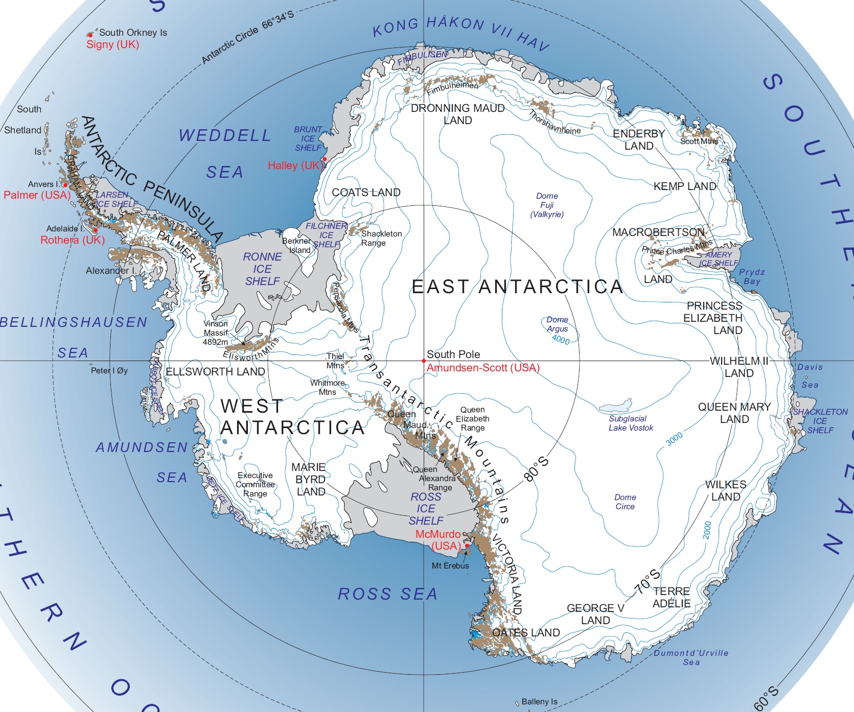
West Antarctic is an area nearly devoid of atmospheric and climate information, with the only previous related scientific campaign to the area occurring in 1957. The West Antarctic Ice Sheet (WAIS) is experiencing rapid changes in temperature and stability, without any comprehensive explanation for the dramatic warming. Due to the lack of data, any attempt to explain the changes cannot be quantified. To help fill this data gap, the second ARM Mobile Facility (AMF2) will be deployed at McMurdo Station, at the southern tip of Antarctica’s Ross Ice Shelf, from October 2015 to September 2016 for the ARM West Antarctic Radiation Experiment (AWARE). A subset of critical AMF2 instruments will operate from the WAIS drilling camp during austral summer 2015-2016.
AWARE will jointly use the capabilities of the U.S. Antarctic Program and the AMF2 to provide quantitative data about energy components, changing air masses, and cloud microphysical data to improve model simulations of the ice sheet as influenced by global climate. These data, gathered by cloud radars, high spectral resolution lidar, aerosol instrumentation, and spectral radiometers, will be vital in creating the first well-calibrated measurements acquired from this remote area.
Principal Investigator: Dan Lubin, University of California, San Diego
Evaluation of Routine Atmospheric Scientific Measurements using Unmanned Systems (ERASMUS)
")
As the popularity of unmanned aircraft systems (UAS) rises, the practical uses of them increase in viability. Because of the advantages afforded by remote operations, these systems can be instrumental in providing scientific information about atmospheric conditions—particularly properties related to clouds, aerosols, and radiation—through routine measurement in harsh or dangerous conditions.
The Evaluation of Routine Atmospheric Scientific Measurements using Unmanned Systems (ERASMUS) is a two-week campaign at Oliktok Point, Alaska, in April 2015. This campaign serves two main purposes: to support the set of atmospheric measurements obtained concurrently by the third ARM Mobile Facility stationed at Oliktok Point; and to evaluate the potential for future routine UAS operations to gather atmospheric measurements at Oliktok Point.
As ice and snow in the Arctic continues to decrease, better understanding of atmospheric processes in higher latitudes becomes increasingly relevant. Measurements from DataHawk and Pilatus UAS excursions will improve understanding of the lower Arctic atmosphere, including aerosols and clouds, by providing vital data for analyses and model studies.
Principal Investigator: Gijs De Boer, University of Colorado–Boulder
ARM Airborne Carbon Measurement (ACME) IV/V

The ARM Airborne Carbon Measurement (ARM-ACME) campaign is back for two more years. This long-term campaign supports studies of atmospheric composition and carbon cycling in North America. ACME IV will log 300 flight hours on the Cessna 206, measuring trace gases in the atmosphere over the ARM Southern Great Plains site in Oklahoma from October 2013 to September 2014. Measurements from this campaign will give researchers insight on the trends and variables of greenhouse gases in the atmosphere. It will also provide comparative data for satellite measurements of carbon dioxide.
In 2015, the ACME campaign moves from the mid-latitude U.S. Great Plains to the Arctic latitude of the North Slope of Alaska. The ARM Aerial Facility’s Gulfstream-159 (G-1) will be based out of Deadhorse, Alaska, near the new installation of ARM’s third mobile facility at Oliktok Point. For three months in the summer of 2015, the G-1 will obtain measurements in this area to continue the study of atmospheric composition and carbon cycling.
The carbon cycle refers to how carbon dioxide and other greenhouse gases circulate and interact with land, oceans, and ecosystems. It is one of the critical cycles in making the Earth suitable for life.
Principal Investigator: Sebastien Biraud, Lawrence Berkeley National Laboratory
The ARM Climate Research Facility is a DOE Office of Science user facility. The ARM Facility is operated by nine DOE national laboratories, including .
Follow Us:


Keep up with the Atmospheric Observer
Updates on ARM news, events, and opportunities delivered to your inbox
ARM User Profile
ARM welcomes users from all institutions and nations. A free ARM user account is needed to access ARM data.


