

First Use of ARM’s New FAA-Approved Arctic Airspace
Published: 3 August 2015
New area offers opportunity to test manned and unmanned aerial systems in the Arctic
After gaining Federal Aviation Administration (FAA) approval, new special-use arctic airspace will be available as a tool to conduct climate and atmospheric research and address scientific questions by gathering additional data under conditions unique to the area.
Called Warning Area W-220 by the FAA, the airspace is 40 miles wide. It starts just offshore of the Atmospheric Radiation Measurement (ARM) Climate Research Facility’s Oliktok Point, Alaska, site and stretches 700 miles north ending 400 miles short of the North Pole so as not to intrude into other nations’ airspaces. The new area expands the U.S. Department of Energy (DOE) research footprint in the Arctic and provides a safety margin for research operations focused on harsh atmospheric and climate conditions found in the Arctic.
More Research Opportunities
“Gaining the warning area was a big win for DOE’s ARM facilities because it opens up the Arctic for new Office of Science research efforts,” said Mark Ivey, manager of ARM’s North Slope of Alaska sites at Oliktok and Barrow and researcher at Sandia National Laboratories, who spearheaded the FAA approval effort.
“In the spirit of collaboration, ARM will maintain its science mission but leave open opportunities for other U.S. agencies and private sector entities, such as oil companies, to come in through the front door of the ARM campaign proposal process and conduct arctic-related research, including environmental studies or testing UAS technology in arctic conditions,” said Ivey. “It makes it possible to do things out there that we couldn’t do otherwise.”
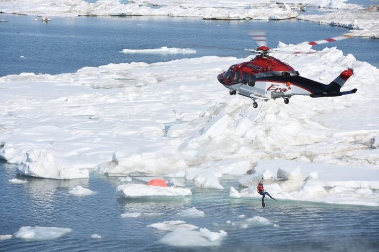
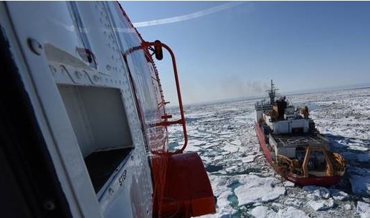
While the U.S. Coast Guard Research and Development Center was the first to lead a collaborative research effort using the new warning area this summer with a campaign focused on saving lives, the ARM Facility also benefited from observing the use of UAS in the search-and-rescue exercise. The joint civil and federal exercise involved deploying a six-man life raft and life-size heated dummy at sea to determine if UAS technology could be effective in locating survivors in the Arctic Ocean, helping manned ships and aircraft come to the rescue, and providing situational awareness of the recovery effort from overhead.
“This arctic exercise taught us quite a few important lessons,” according to Ivey. “First, we worked through the first activation of the warning area with two FAA reps on-site. That turned out to work great. We used the wiki [collaborative web technology] to communicate information and also had one member of our team at a NORAD radar scope in Anchorage, clearing the area prior to the UAS launch. That was critical to the UAS exercise. These experiences will be important in establishing safe operational procedures for future ARM scientific campaigns using the warning area.”
UAS Technology Proves Viable
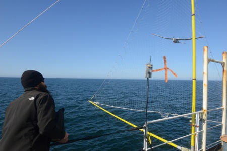
To locate the life raft and dummy on the first day of the trials, a UAS was launched from Oliktok Point and the Coast Guard Cutter Healy successfully took control and directed it in a search pattern designed to locate the targets. Locating the target proved to be a challenge in the ice-covered waters and the Healy was obliged to guide the UAS to the right spot where it stayed and observed the manned aircraft recovery efforts. The next day, the team flew a second UAS, owned by the National Oceanic and Atmospheric Administration (NOAA), and encountered similar issues. This time, the team was able to remain at the targets and pass updated position information to guide the rescuers to the targets before they left land at Deadhorse, Alaska.
Both tests demonstrated that UAS technology can be a resource in future operations by supplementing manned rescue efforts and providing situational awareness. Real-time video imagery transmitted from both units illustrated how UAS technology can provide climate researchers with useful information for answering questions about atmospheric conditions.
“Overall, we accomplished our objectives with this exercise,” said Lieutenant Keely Higbie of the Coast Guard’s Research and Development Center in New London, Connecticut. “We anticipated that the exercise wouldn’t go perfectly, but we learned a lot about the successes and shortcomings of using UAS for search-and-rescue operations.”
The search-and-rescue operation involved collaboration with the DOE, FAA, ConocoPhillips, Insitu, Era Helicopters, NOAA, and others.
“For the Coast Guard, this exercise was also about civil/federal collaboration,” Higbie explained. “In the event of a major incident, we want to understand how to work with all entities on the North Slope. Assets and resources are scarce up there and oil companies are required to have search-and-rescue and oil-spill response capabilities. We need to understand how to leverage those capabilities and those provided by the North Slope Borough and Alaska Clean Seas. This was a great exercise to work out those details.”
Safety a Priority
Collaboration and safety, as well as research applications were also priorities for ARM researchers during the Coast Guard exercise, according to Ivey, who pointed out that when the decision was made to seek approval for a larger research area, aircraft safety was a major concern.
“In 2004, we were granted a four-mile diameter restricted area around Oliktok Point, our base of operations for atmospheric measurements,” he explains. Restricted areas are for U.S. airspace and warning areas apply to international airspace.
“That was renewed in 2010, but we saw the potential for more extensive, ongoing experiments creating renewed interest in operating offshore. It was clear to everyone that balloons with sensors tethered in low clouds could pose dangers to aircraft, especially the small private planes that operate in Alaska.”
Warnings for Pilots
Ivey and Bernie Zak, former science liaison for the ARM North Slope Site, applied and reapplied for the larger space, which extends over international waters and provides a significant safety margin for researchers by warning other pilots about scientific traffic in the area. The ARM Facility, and others who use W-220, will take advantage of the FAA Notices to Airmen Service (NOTAMS) to alert aircraft in the area when flights for research and other authorized purposes are being conducted.
“Thanks to support from the DOE Office of Science, we were able to stay the course and get FAA approval to use this important airspace,” Ivey concluded.
During summer 2015, ARM researchers plan to conduct another UAS field campaign at Oliktok Point and will also begin routine tethered balloon operations to study atmospheric structure in the Arctic.
# # #
The ARM Climate Research Facility is a national scientific user facility funded through the U.S. Department of Energy’s Office of Science. The ARM Facility is operated by nine Department of Energy national laboratories, including Sandia National Laboratories, which manages ARM’s activities at the Oliktok site.
The ARM Climate Research Facility is a DOE Office of Science user facility. The ARM Facility is operated by nine DOE national laboratories, including .
Follow Us:


Keep up with the Atmospheric Observer
Updates on ARM news, events, and opportunities delivered to your inbox
ARM User Profile
ARM welcomes users from all institutions and nations. A free ARM user account is needed to access ARM data.


