

Remote Region Promotes Remote-Control Science
Published: 3 August 2015
ERASMUS field campaign deploys August 2015
With ice and snow in the Arctic decreasing, improving understanding of atmospheric processes at high latitudes becomes an increasingly critical task for climate scientists. Researchers are using remote-controlled unmanned aerial systems in Oliktok Point, Alaska, this summer to collect hard-to-gather data with the ultimate aim of improving climate models.
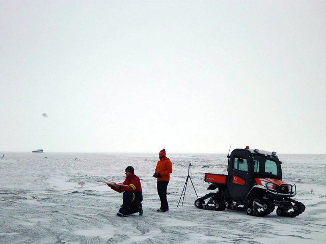
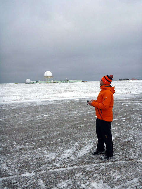
These unmanned aerial systems are small aircraft capable of operating autonomously using onboard autopilot, or in a remotely-controlled mode, where pilots guide the aircraft directly from the ground. Onboard instrumentation provides cost-effective insight into previously unreachable areas, such as the atmosphere over the water and ice surface of the Arctic Ocean or at several hundred meters above the surface, while the scientists and operators remain on land.
Beginning in August, the Atmospheric Radiation Measurement (ARM) Climate Research Facility is hosting the Evaluation of Routine Atmospheric Sounding Measurements Using Unmanned Systems, or ERASMUS, campaign at Oliktok. ERASMUS will demonstrate how unmanned aerial systems can be used to continuously study the Arctic’s atmosphere while simultaneously providing observations to better understand different processes related to the cloud life cycle. These measurements will be complimentary to those concurrently obtained by the third ARM Mobile Facility (AMF3) ground instrumentation, deployed at the site, which give scientists expanded measurements to study Arctic clouds, aerosols, and other atmospheric phenomena. ERASMUS will take place over two, two-week long deployments in August 2015 and spring 2016.
“We have been preparing for this campaign for nearly two years and are very excited to head to the field to carry out our operations,” said ERASMUS principal investigator Gijs de Boer of the upcoming deployment. “These measurements should provide some unique insights into the lower arctic atmosphere that we did not previously have available to us as atmospheric scientists.”
Data Collection
The ERASMUS team will utilize two very different unmanned aerial systems—the DataHawk and Pilatus.
The DataHawk is a very small and lightweight airplane outfitted with instruments to measure temperature, humidity, and pressure and to estimate wind speed. It weighs in at just over two pounds and features an almost 40-inch wingspan. It is easy to transport, set up, and does not need special preparation to operate—all key characteristics when flying in such remote locations. ERASMUS will use this aircraft in August 2015 to observe the evolution temperature humidity and winds over the lowest 2 kilometers of the atmosphere.
The second aircraft, the Pilatus, features unique observing capabilities related to measurement of atmospheric aerosol particles and energy transfer. This information is critical to understanding processes related to cloud formation, and the absorption and reflection of energy between the Earth’s surface and space. In addition, Pilatus will be used to measure temperature, humidity, and pressure in the atmosphere. These combinations of instruments require this aircraft to carry substantially more weight than can be handled by a plane the size of the DataHawk. Therefore, the Pilatus is substantially larger, with a 10.5-foot wingspan and a nearly 50 pound weight. The Pilatus is scheduled to operate during ERASMUS’ early spring 2016 launch.
Together, the unmanned aerial systems and AMF3 instrumentation, provide substantially improved insight into modeled processes at scales relevant to climate models.
Meet the Team
Principal investigator Gijs de Boer, research scientist at the University of Colorado, is working closely together with AMF3 site manager Mark Ivey of Sandia National Laboratories. Together, they will lead a team of scientists from the Cooperative Institute for Research in Environmental Sciences (CIRES) and Aerospace Engineering Department at the University of Colorado-Boulder. The team is also collaborating with the National Oceanic and Atmospheric Administration (NOAA), the National Aeronautics and Space Administration (NASA), and U.S. Department of Energy laboratories to prepare aircraft and instruments and work through the logistics of deployment of the ERASMUS campaign.
To follow the campaign, read de Boer’s blog.
# # #
The ARM Climate Research Facility is a national scientific user facility funded through the U.S. Department of Energy’s Office of Science. The ARM Facility is operated by nine Department of Energy national laboratories, including Sandia National Laboratories, which manages ARM’s activities at the Oliktok site.
The ARM Climate Research Facility is a DOE Office of Science user facility. The ARM Facility is operated by nine DOE national laboratories, including .
Follow Us:


Keep up with the Atmospheric Observer
Updates on ARM news, events, and opportunities delivered to your inbox
ARM User Profile
ARM welcomes users from all institutions and nations. A free ARM user account is needed to access ARM data.


