

Sleepless on the Great Plains
Published: 22 May 2015
More than 100 researchers and dozens of support staff will spend 25 sleepless nights on the ground and in the air this summer, using an array of instruments to help them understand why the rain in the Great Plains falls mainly in the dark.
Their marathon of wakefulness is called PECAN, the Plains Elevated Convection at Night field campaign. It is a collaborative effort conceived to help scientists find answers to pressing questions about sometimes damaging nighttime thunderstorms over the Great Plains—and to help develop better climate and weather models.
“This is a weather phenomenon that climate models don’t get right,” said David Turner, National Oceanic and Atmospheric Administration (NOAA) National Severe Storms Laboratory scientist and lead investigator for the ARM-funded support for PECAN. “PECAN will help us gain insight into what is happening, and how we can incorporate that into models to improve their predictive capability.”
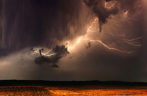
Most thunderstorms form during the day when sunlight warms the ground and the air above it. Such storms are easy to explain because warm air generated near the ground rises and cool air flows down to replace it, creating convection that can give rise to thunderheads and heavy rains. When thunderstorms occur at night, however, they are more difficult to explain because the Earth is cooling and convection currents that generate them form at higher altitudes. Researchers hope to improve their understanding of how elevated convection starts at night and how it evolves.
A large fraction of the annual rainfall in the Great Plains is the result of these nighttime storms, which are not associated with the ground. The storms are known to be touched off by wave disturbances called “bores” (colliding masses of air at different temperatures), low-level jet streams, and other higher atmospheric phenomena.
Unprecedented Effort
Considering the nocturnal nature of the convection and the physical size of the central Great Plains, it’s easy to see why the PECAN project requires the collaborative efforts of 8 research laboratories and 14 universities with financial support from several sources. Along with other institutions, the National Center for Atmospheric Research (NCAR) co-organized the campaign. NCAR’s sponsor, the National Science Foundation (NSF), contributed $10.6 million of the $13.5 million allocated for the project. Other sponsors include the National Aeronautical and Space Administration (NASA), NOAA, and U.S. Department of Energy’s Office of Science, who provided the rest of the funding support.
“This set of resources has never been put in the field before and is only possible because of interagency cooperation,” Turner said.
Instrumentation necessary to cover the large research domain, which includes most of western and central Kansas, northern Oklahoma, and southern Nebraska is provided by the collaborators and will enable the researchers to collect data higher in the atmosphere.
Unique Instrumentation
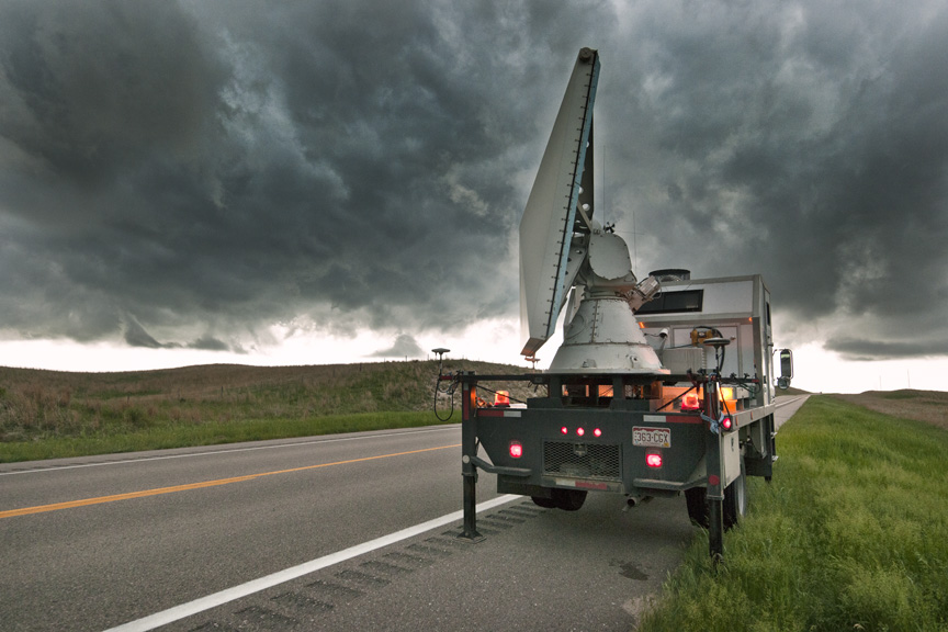
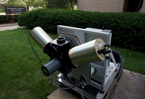
Instrumentation for the campaign includes a unique component system called the PECAN Integrated Sounding Array (PISA). There will be six fixed PISAs in the research area and four mobile PISAs will be moved nightly, along with dozens of people. Each PISA has remote-sensing devices that can profile temperature, humidity, and winds throughout the boundary layer and lower troposphere in approximately five-minute intervals. Radiosonde systems will also be collocated with the PISAs to provide additional information at all levels up to the lower stratosphere. Scientists will also have a fleet of mobile and fixed radars to provide additional data.
The six ARM Facility AERIs, along with data from the Enhanced Soundings for Local Coupling Studies, will provide uniform and consistent temperature data across the domain to help scientists gain a better understanding of pre-convective and convective processes. Additional support from the ARM Facility includes a radiosonde system that will be located at one of the fixed PISA locations. The full PISA data set will become public domain after the field campaign and is expected to be useful to all scientists for data assimilation and prediction studies.
“This is an excellent technical demonstration of what you would get if you had a network of AERIs,” Turner said. “This will help us understand the right density for these instruments at the SGP site.”
For more information: Read the NOAA press release and NSF press release. An open house will be held in Hays, Kansas, May 30.
# # #
The ARM Climate Research Facility is a national scientific user facility funded through the U.S. Department of Energy’s Office of Science. The ARM Facility is operated by nine Department of Energy national laboratories.
The ARM Climate Research Facility is a DOE Office of Science user facility. The ARM Facility is operated by nine DOE national laboratories, including .
Follow Us:


Keep up with the Atmospheric Observer
Updates on ARM news, events, and opportunities delivered to your inbox
ARM User Profile
ARM welcomes users from all institutions and nations. A free ARM user account is needed to access ARM data.


