ARM Facility Captures Rare Tornado Data
Published: 29 May 2013
Every spring, tornadoes thunder across five states, from Kansas to Texas, and alerts are common. However, by Monday, May 20, it was clear that this time the alert had a different urgency to it. The turn of events leading up to the EF-5 tornado that wreaked havoc in Moore, Oklahoma, provided a unique opportunity for scientists to sample the environment preceding a severe weather event.

The U.S. Department of Energy’s Atmospheric Radiation Measurement (ARM) Climate Research Facility maintains one of the most sophisticated climate and weather stations in the world in north-central Oklahoma. Daily operations at the ARM Southern Great Plains (SGP) site include weather balloon, or radiosonde, launches every four hours to collect vertical data of atmospheric state, which is useful for validating satellite measurements.
On the Thursday before the storm, the site received an emergency request from Dave Tobin, an atmospheric scientist at the University of Wisconsin, to launch supplementary radiosondes over the the weekend and on Monday. Tobin is the principal investigator of an ongoing NOAA-sponsored satellite validation field campaign based at SGP. He had anticipated the potential for an unusual weather event and contacted Donna Holdridge, ARM instrument mentor for the balloon-borne sounding system. He asked if she could coordinate extra sonde launches at the site during satellite overpasses and a flight plan he had filed for the NASA ER-2 in the area.
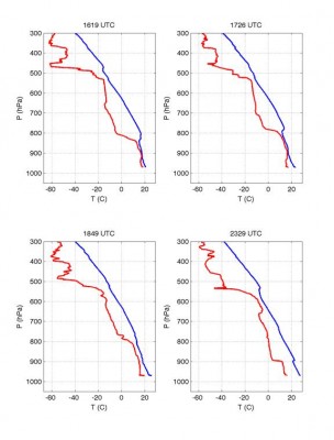
Acting quickly, Holdridge and the team at SGP coordinated and confirmed the extra launches between May 18-20, capturing the buildup of conditions leading to the 1.3-mile-wide massive twister.
“Thanks very much for coordinating the sonde launches yesterday, and please extend our thanks to all the staff,” said Tobin in an email to Holdridge. “The ER-2 was over Oklahoma yesterday mid morning to early afternoon and, along with the satellite data and radiosonde data, we expect it to be very useful in diagnosing the pre-convective storm environment prior to the devastating tornado.”
Scientists can use these data to provide insights into the convective nature of the atmosphere preceding severe tornadoes—research that can potentially improve severe weather prediction. The radiosonde data are available in the ARM Data Archive.
The ARM Climate Research Facility is a DOE Office of Science user facility. The ARM Facility is operated by nine DOE national laboratories, including .
Keep up with the Atmospheric Observer
Updates on ARM news, events, and opportunities delivered to your inbox
ARM User Profile
ARM welcomes users from all institutions and nations. A free ARM user account is needed to access ARM data.


