
ICECAPS
Lidar support for ICECAPS at Summit, Greenland
15 April 2010 - 25 May 2025
Lead Scientist: Matthew Shupe
Observatory: osc, smt osc
Beginning in May 2010, the Integrated Characterization of Energy, Clouds, Atmospheric State, and Precipitation over Summit (ICECAPS) project, funded through the National Science Foundation’s Arctic Observing Network, is deploying a suite of remote sensors at Summit, Greenland.
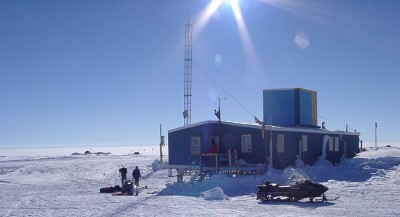
With dining facilities and communications gear, the “Big House” at Summit Station serves as the central gathering area for site researchers. (Photo courtesy Summit Station.)
The instrument suite includes a millimeter-wave cloud radar (MMCR), Atmospheric Emitted Radiance Interferometer (AERI), microwave radiometer profiler, a high-frequency microwave radiometer, microwave precipitation sensor, and other instruments. The project also includes twice-daily radiosonde launches. ARM is contributing to this campaign with a micropulse lidar (MPL) and Vaisala ceilometer to gather information about optically thin clouds commonly found above the Summit site. Combined measurements from these sensors and instruments will result in a comprehensive data set of cloud properties, atmospheric state, precipitation, and radiation. Various modeling studies have shown that the Arctic is very sensitive to man-made climate change. Data from ICECAPS data will provide a complementary data set to ongoing measurements gathered at ARM’s North Slope of Alaska site in Barrow, and the SEARCH site in Eureka, Canada, helping scientists reach a better understanding of the role that clouds play in the radiative budget of the Arctic. The MPL and ceilometer datastreams will be made available in the ARM Data archive, along with other ICECAPS datastreams.
Science Team
David Turner, Lead Principal Investigator, University of Wisconsin - Madison
Matthew Shupe, Co-Investigator, University of Colorado
Von Walden, Co-Investigator, University of Idaho
Co-Investigators
| Von Walden |
Timeline
Related Publications
2022
Guy H, D Turner, V Walden, I Brooks, and R Neely. 2022. "Passive ground-based remote sensing of radiation fog." Atmospheric Measurement Techniques, 15(17), 10.5194/amt-15-5095-2022.
Sterzinger L, J Sedlar, H Guy, R Neely III, and A Igel. 2022. "Do Arctic mixed-phase clouds sometimes dissipate due to insufficient aerosol? Evidence from comparisons between observations and idealized simulations." Atmospheric Chemistry and Physics, 22(13), 10.5194/acp-22-8973-2022.
2020
Goss HB, KS Dorsey, CB Ireland, MR Wasem, RA Stafford, and R Jundt. 2020. 2019 Atmospheric Radiation Measurement (ARM) Annual Report. Ed. by Kathryn Dorsey, ARM user facility. DOE/SC-ARM-19-032. 10.2172/1604869.
2016
Pettersen C, R Bennartz, MS Kulie, AJ Merrelli, MD Shupe, and DD Turner. 2016. "Microwave signatures of ice hydrometeors from ground-based observations above Summit, Greenland." Atmospheric Chemistry and Physics, 16(7), 10.5194/acp-16-4743-2016.
Van Tricht K, S Lhermitte, TM Lenaerts, IV Gorodetskaya, TS L'Ecuyer, B Noel, MR van den Broeke, DD Turner, and NP van Lipzig. 2016. "Clouds enhance Greenland ice sheet meltwater runoff." Nature Communications, 7, 10266, 10.1038/ncomms10266.
2015
Cox CJ, PV Walden, PM Rowe, and MD Shupe. 2015. "Humidity trends imply increased sensitivity to clouds in a warming Arctic." Nature Communications, 6, 10117, 10.1038/ncomms10117.
2013
Shupe MD, DD Turner, VP Walden, R Bennartz, M Cadeddu, B Castellani, C Cox, D Hudak, M Kulie, N Miller, RR Neely, III, W Neff, and PM Rowe. 2013. "High and Dry: New Observations of Tropospheric and Cloud Properties above the Greenland Ice Sheet." Bulletin of the American Meteorological Society, 94(2), 10.1175/bams-d-11-00249.1.
Research Highlight
2012
Miller N, C Pettersen, VP Walden, DD Turner, M Shupe, R Bennartz, WD Neff, C Cox, M Kulie, and B Castellani. 2012. What Triggered the Recent Melt Event at Summit, Greenland? Insights from an Integrated Suite of Ground-Based Observations. Presented at Fall American Geophysical Union Meeting. San Francisco, CA.
Neely III RR, M Hayman, JP Thayer, RM Hardesty, M O'Neill, M Shupe, and R Stillwell. 2012. First Year of Data From the Polarization LIDAR for the Detection of Cloud Phase, Particle Orientation and Stratospheric Aerosol At Summit, Greenland. Presented at 92th Annual American Meteorological Society (AMS) Meeting. New Orleans, LA.
Neff WD, M Shupe, FM Ralph, G Compo, and DD Turner. 2012. On the Origins of the Recent Greenland Melt in the US 2012 Heat Wave. Presented at Fall American Geophysical Union Meeting. San Francisco, CA.
View All Related Publications