Observational and modeling study of ice hydrometeor radar dual-wavelength ratios
Submitter:
Matrosov, Sergey — University of Colorado
de Boer, Gijs — University of Colorado Boulder
Area of research:
Cloud Processes
Journal Reference:
Science
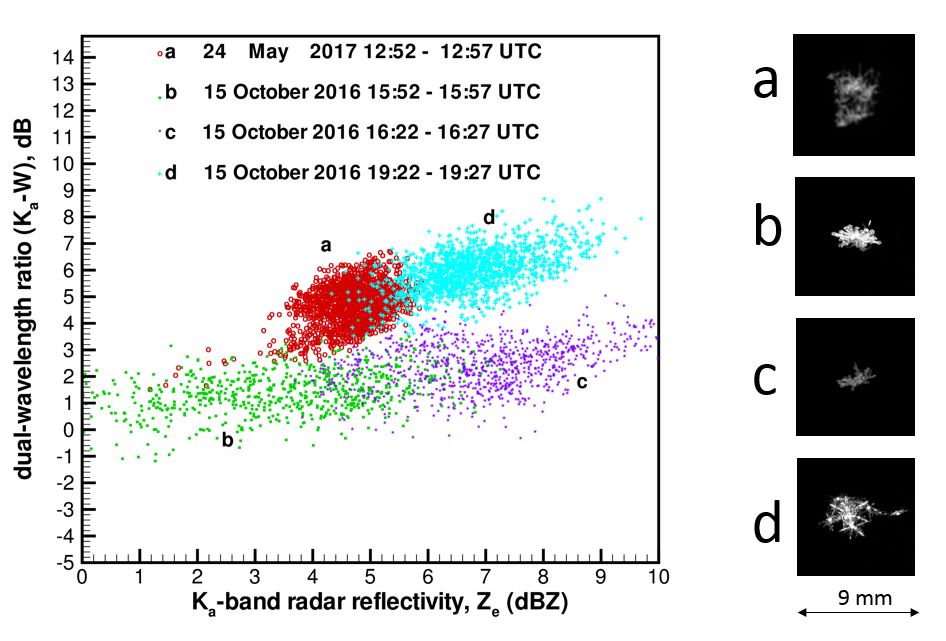
This study demonstrates that in ice clouds and precipitation the difference between reflectivities at two cloud radar frequencies (i.e., the dual-wavelength ratio, or DWR) and absolute reflectivity, Z, at lower frequency are well correlated. A rate of the DWR increase with increasing Z can be used to infer information on larger ice hydrometeor general shape expressed as the mean particle aspect ratio.
Impact
Inferring hydrometeor aspect ratios from vertically pointing dual-wavelength cloud radar data does not require polarimetric scanning measurements, which are typically used for particle habit identification. DWR data can be used to study important cloud and precipitation processes such as riming and aggregation.
Summary
Measurements of ice hydrometeors using a Ka (35 GHz)–W (94 GHz) dual-frequency cloud radar show that, for vertically pointing measurements, dual-wavelength ratio (DWR) increasing trends with reflectivity, Z, are very pronounced when Ka-band Z is greater than about 0 dBZ, and DWR and Z values are well correlated. This correlation is explained by strong relations between hydrometer characteristic size and both of these radar variables. The observed DWR variability for a given level of reflectivity is as large as 8 dB, which is in part due to changes in mean hydrometeor shape as expressed in terms of the particle aspect ratio. Hydrometeors with a higher degree of nonsphericity exhibit lower DWR values compared to quasi-spherical particles due to near-zenith reflectivity enchantments for larger scatterers. When particle mass-size relations do not change significantly (e.g., for low-rime conditions), DWR can be used to differentiate between quasi-spherical and highly nonspherical hydrometeors, as (for a given reflectivity value) DWR tends to increase as particles become more spherical. Initial analysis of collocated spaceborne CloudSat radar (95 GHz) and ground-based operational (3 GHz) radars confirms the ability of DWR estimates to provide information on particle shapes.