
ARM cloud radar simulator: A new tool for bridging field data and climate model
Submitter:
Xie, Shaocheng — Lawrence Livermore National Laboratory
Zhang, Yuying — Lawrence Livermore National Laboratory
Area of research:
Cloud Processes
Journal Reference:
Science
Significant differences exist between how a climate model represents clouds and what instruments observe, both in terms of spatial scale and the properties of the hydrometeors that are either modeled or observed. To address these issues and minimize impacts of instrument limitations, this study developed an ARM radar simulator that converts model variables to what a cloud radar can directly observe, i.e., radar reflectivity, to facilitate and improve the comparison of modeled clouds with ARM detailed cloud observations.
Impact
The ARM radar simulator was developed by utilizing the QuickBeam radar simulator, implemented in the Cloud Feedback Model Intercomparison Project (CFMIP) Observation Simulator Package (COSP), to facilitate the comparison of climate-model-simulated clouds with ARM cloud observations such that comparisons can be done more easily and routinely, and provide insight into model performance. This work also enhances the capability of COSP so that it can simulate cloud radar reflectivities from ground-based radars that ARM operates at its research sites. It is hoped that incorporating the ARM simulator within COSP will greatly facilitate its use by the climate modeling community.
Summary
For illustrative purposes, we applied the ARM radar simulator to the DOE Energy, Exascale, and Earth System Model (E3SM) atmosphere model version 0 and evaluated its simulated clouds. One unique feature of ARM cloud radar observations with high temporal resolution is that they allows examination of detailed cloud vertical structures over the diurnal cycle. For non-precipitating clouds with radar reflectivities less than -20 dBZ, the model fails to capture the occurrence of shallow cumulus clouds that grow atop the daytime boundary layer (compare Figures 1a and 1b). For precipitating hydrometeors, estimated by the occurrence of reflectivities larger than -20 dBZ, the model significantly overestimates clouds at all levels. Also, modeled precipitating clouds peaked in the afternoon around 4 PM LST (Figure 1d), in contrast to the corresponding peak in the observations near midnight (Figure 1c). These model errors are quite common in current climate models. The ARM simulator provides additional evaluation with more detailed cloud information. Future work includes further improvements of ARM CFAD data quality via uncertainty quantification and better calibration of ARM cloud radar data. We are also considering adding diurnal cycle metrics (similar to Figure 1) to the simulator for ease of use by the community.
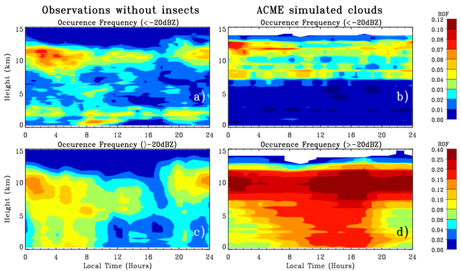
Figure 1. Observed (a and c) and modeled (b and d) diurnal cycles of clouds during the summer months (i.e., May, June, July, and August) of 2009. a) and b) are the relative occurrence frequencies (ROF) of non-precipitating clouds and c) and d) are the relative occurrence frequencies of precipitating clouds.