MAGIC Ship-Based Observations Help Validate Satellite Microwave Liquid Water Path
Submitter:
Painemal, David — NASA LaRC /AMA
Minnis, Patrick — NASA - Langley Research Center
Area of research:
Cloud Distributions/Characterizations
Journal Reference:
Science
Satellite-based passive microwave (MW) liquid water path (LWP) is a fundamental quantity for climate studies, climate model validation, and validation of satellite visible/near-infrared retrievals over the oceans. Unfortunately, the lack of independent observations has prevented the evaluation of MW LWP, and thus the accuracy of satellite MW-derived LWP remains uncertain. The ship deployment of the Department of Energy Atmospheric Radiation Measurement (ARM) Mobile Facility (AMF) over the northeast Pacific during 2012-2013 as part of the Marine ARM GPCI Investigation of Clouds (MAGIC), offered an unprecedented data set for satellite MW LWP evaluation, with measurements made along the nearly 4,000-km ship transect from the port of Los Angeles, California (33.7˚N, 118.2˚W) to Honolulu, Hawaii (21.3˚N, 157.8˚W).
Impact
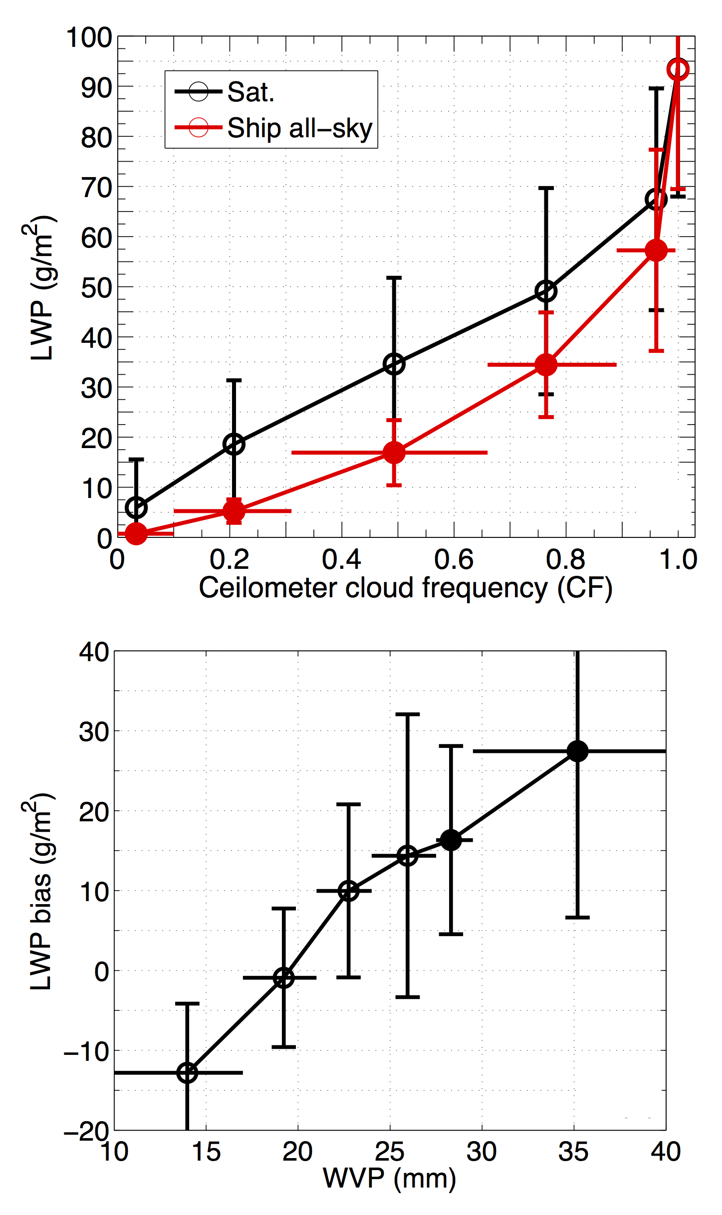
Ship-based LWP retrievals from a three-channel microwave radiometer and cloud detection from a laser ceilometer were used to validate low-cloud retrievals from four satellite sensors. We analyzed the retrieval dependence on cloud cover and the ability of the combined satellite sensors to reproduce the LWP diurnal cycle. The overall result is remarkable due to the close agreement between satellite and MAGIC campaign observations for overcast scenes. However, we found an overestimation of satellite MW LWP in partially cloudy scenes, which increases linearly with water vapor, suggesting a direct effect of water vapor path on the measured brightness temperature.
Summary
We present the first extended validation of satellite microwave (MW) liquid water path (LWP) for low non-precipitating clouds, from four operational sensors, against ship-borne observations from a three-channel MW radiometer collected along ship transects over the Northeast Pacific during May-August 2013. Satellite MW retrievals have an overall correlation of 0.84 with ship observations and a bias of 9.3 g/m2. The bias for broken-cloud scenes increases linearly with water vapor path and remains below 17.7 g/m2. In contrast, satellite MW LWP is unbiased in overcast scenes with correlations up to 0.91, demonstrating that the retrievals are accurate and reliable under these conditions. Satellite MW retrievals produce a diurnal cycle amplitude consistent with ship-based observations (33 g/m2). Observations taken aboard extended ship cruises offer a new way to evaluate not only satellite MW LWP, but also LWP derived from visible/infrared sensors.