KDP columns: Characterizing deep thunderstorm updrafts using polarimetric radar
Submitter:
van Lier-Walqui, Marcus — Columbia University
Fridlind, Ann M. — NASA - Goddard Institute for Space Studies
Area of research:
Cloud-Aerosol-Precipitation Interactions
Journal Reference:
Science
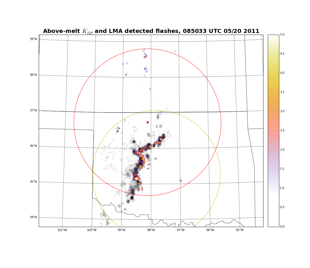
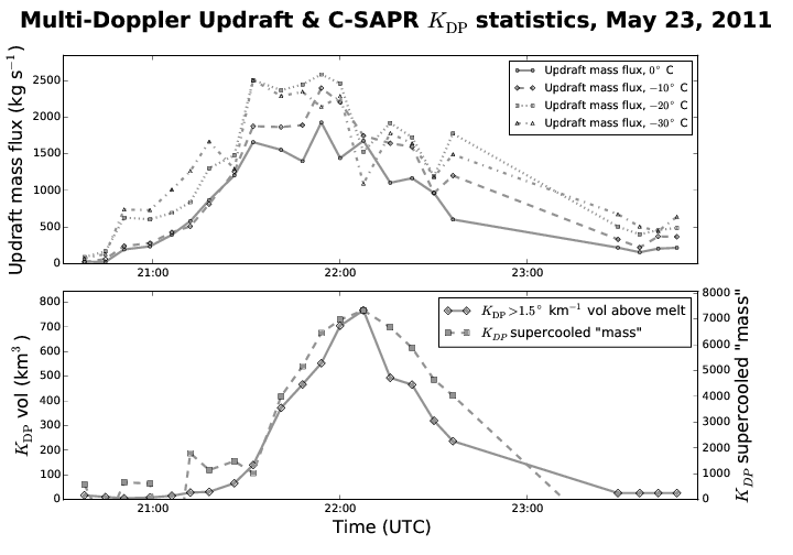
The representation of deep convection in general circulation models is in part informed by cloud-resolving models (CRMs) that function at higher spatial and temporal resolution; however, recent studies have shown that CRMs often fail at capturing the details of deep convection updrafts. With the goal of providing constraint on CRM simulation of deep convection updrafts, ground-based remote-sensing observations were analyzed and statistically correlated for four deep convection events observed during the Midlatitude Continental Convective Clouds Experiment (MC3E). Since positive values of specific differential phase (KDP) observed above the melting level are associated with deep convection updraft cells, so-called “KDP columns” were analyzed using two scanning polarimetric radars in Oklahoma: the National Weather Service Vance WSR-88D (KVNX) and the Department of Energy C-band Scanning Atmospheric Radiation Measurement (ARM) Precipitation Radar (C-SAPR). KVNX and C-SAPR KDP volumes and columns were then statistically correlated with vertical winds retrieved via multi-Doppler wind analysis, lightning flash activity derived from the Oklahoma Lightning Mapping Array, and KVNX differential reflectivity (ZDR). Throughout, the Python ARM Radar Toolkit (Py-ART) was used to process and grid radial radar data.
Impact
When intense updrafts occur inside of thunderstorms, a common characteristic is the lofting of rain and/or liquid-coated hail to heights well above the environmental melting level. These hydrometeors are observable by polarimetric radars, due to the oblateness of these hydrometeors, as positive enhancements in KDP and ZDR that are roughly collocated with the updraft location. KDP and ZDR columns thus provide an observational proxy for deep convection updrafts, updrafts that are usually only detectable by non-attenuating profiling radars, or derivable by multi-Doppler radar networks. Here we objectively identified KDP columns using a simple, but robust, object-identification algorithm. For each KDP column, horizontal and vertical extent, and maximum retrieved vertical velocity were quantified, together with storm-total KDP column volume, ZDR column volume, and lightning flash frequency.
Summary
Our work showed strong correlations of KDP volume above the melting level with updraft mass flux, lightning flash activity, and intense rainfall. These correlations confirm the usefulness of KDP columns for the observational detection and analysis of deep convection updrafts. Weaker correlations were observed between KDP column height and multi-Doppler estimated updraft strength, and together with temporally lagged correlations between KDP column statistics, updrafts, and lightning activity, suggest that future work should focus on observations of the full lifecycle of deep convection updrafts. KDP column heights were shown to be variable between days studied and also show variability within a single day, in accordance with changes in storm morphology. Comparison of ZDR to KDP showed commonalities in the information content of each, as well as potential problems with ZDR associated with observational artifacts, such as differential attenuation, and the reduction in ZDR when radar volumes are contaminated by large hail. These findings suggest that KDP should be used together with ZDR to identify and track deep convection updrafts.