How well are shallow convective clouds simulated in the CAM5 model?
Submitter:
Chandra, Arunchandra S. — University of Miami
Area of research:
Cloud Distributions/Characterizations
Journal Reference:
Science
Low-level clouds have been identified as a key uncertainty in model cloud feedback. This is particularly so in the tropical shallow cumulus regime. Biases in underestimating low-cloud cover have persisted in most recent models, namely those that participated in the Coupled Model Intercomparison Project 5 (CMIP5). In these models, stratocumulus clouds are produced in place of shallow cumulus and low clouds tend to concentrate in the lowest 1 km instead of spread throughout the boundary layer. Models fail to capture the realistic vertical distribution of low clouds because of a weak dependence on large-scale environmental conditions in contrast to observations. A new shallow convection scheme is implemented in CAM5 with discernible improvements in its climate simulations. It is desirable to assess against observations how shallow convective clouds in the tropical deep convection regime are produced in CAM5 with this new parameterization scheme in place. ARM observations at the now retired Tropical Western Pacific (TWP) Manus site are used for the evaluation. One important aspect of this study is adopting a consistent methodology for identifying different cloud types in both models and observations and selecting an optimal time averaging for comparing cloud fraction.
Impact
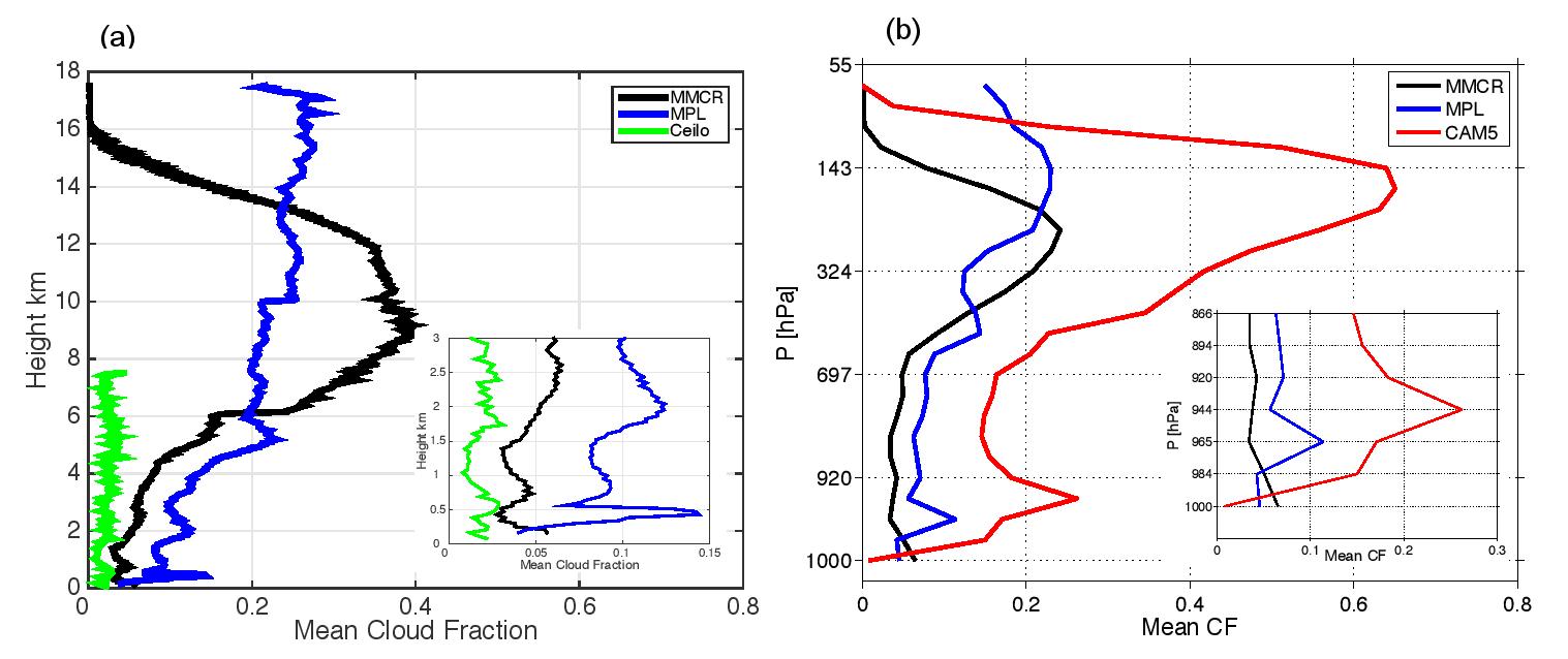
This study evaluates the ability of the Community Atmospheric Model version 5 (CAM5) to reproduce low clouds observed by the Atmospheric Radiation Measurement (ARM) cloud radar at Manus Island during the Years of Tropical Convection (YOTC: May 2008-April 2010). Low clouds are defined with their tops below the freezing level and bases within the boundary layer. To ensure a fair cloud classification for model and observations, a particular cloud type was defined based on the continuity in cloud fraction profiles rather than defining them only based on the averaged cloud top; the latter may misclassify some deep clouds as low clouds. Low clouds were further separated into precipitating and non-precipitating clouds, and rain rate distributions of precipitating clouds were documented. We scrutinized the vertical structures of low clouds using different methods (daily and monthly time series, the diurnal cycle, mean fraction, and probability distribution function profiles, etc.) in the observation-model comparison to ensure the consistency and robustness of the results.
The discrepancies in the vertical distribution of low clouds in the model are quantified and further investigated as to which part of the model is responsible for the low cloud bias. The possible reasons for the low cloud bias in the model are suggested based on the relationship between mixed-layer depth, boundary layer humidity and the cloud fraction.
Summary
CAM5 underestimates total low-cloud events (13% of total cloud hours versus 48% in the observations), overproduces precipitating low-clouds fraction (93% versus 27% in the observations), and overproduces deep clouds (86% versus 25% in the observations). The shallow scheme produces precipitation without rain from the deep scheme for 50% of the total low-cloud events. This suggests that both deep and shallow schemes are responsible for the overproduction of precipitation from low clouds
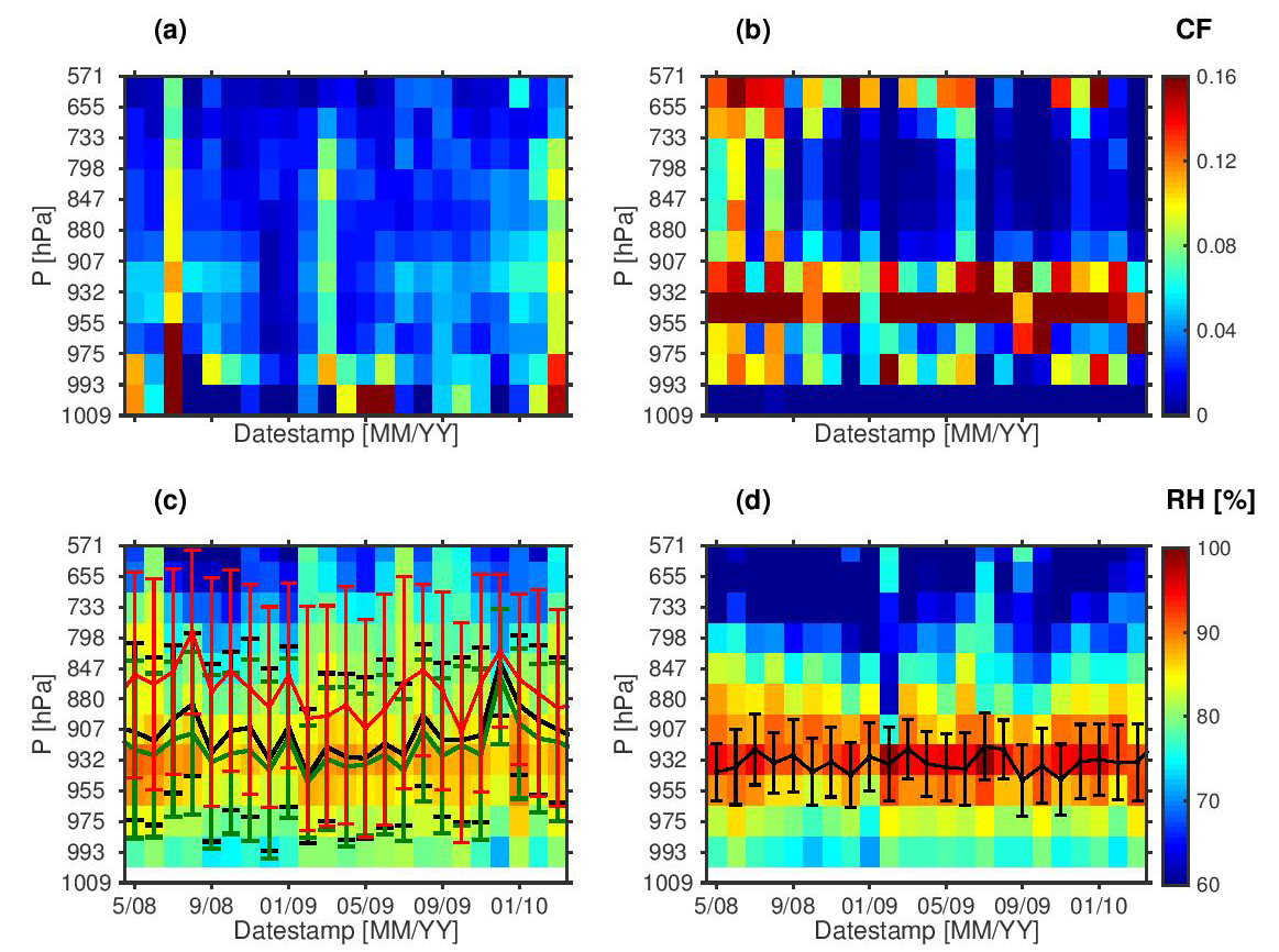
The observed low-cloud fraction shows the typical mean profile that decreases with height. In a stark contrast, the simulated low-cloud fraction peaks spuriously at 955 to 932 hPa. This spurious peak of large cloudiness exists persistently and consistently in many different realizations of the data (daily and monthly time series, the diurnal cycle, mean fractions, and probability distribution function profiles, etc.). By no means should this be interpreted as a result of mismatch between point observations and grid box output of the simulations. It is an unmistakable model error.
The spurious peak of low clouds in the CAM5 simulations coincides with excessive humidity near the top of the mixed layer. It is suggested that the erroneous peak in the low-cloud fraction is produced by the cloud macrophysics scheme in response to the excessive humidity that stems from insufficient vertical mixing and transport.
The absence of the observed diurnal cycle in both low-cloud fraction and boundary-layer humidity at Manus in the simulations cannot be attributed to the unresolved island because of the coarse grid spacing. It must be an indication of deficiencies in model physics.


