Modeling precipitating cumulus congestus observed by the ARM radar suite during the MC3E field campaign
Submitter:
Mechem, David B. — University of Kansas
Area of research:
Cloud Processes
Journal Reference:
Science
Much of the uncertainty in climate model projections stems from the limited understanding of cloud and precipitation processes and the parameterization of these processes in global climate models (GCMs). Typically, results from cloud-resolving models (CRMs) or large-eddy simulation (LES) models serve as benchmarks for developing and tuning single-column models (SCMs), which, in turn, form the basis of parameterizations in GCMs. Thus, LES is positioned as a key component of cloud parameterization development. However, many previous LES studies have deemphasized directly evaluating LES solutions against observational constraints. One explanation for a de-emphasis on observations is that clouds are difficult to reliably sample, and existing observational capabilities are often incompatible with high-resolution LES models.
This study documents a more natural coupling of LES modeling and cloud observing capabilities for the Oklahoma Southern Great Plains (SGP) ground-based supersite, operated by the Department of Energy (DOE) Atmospheric Radiation Measurement (ARM). The site recently complemented its single-column measurements with new scanning radars that may better suit the sampling of LES-scale domains. An application of LES with size-resolved (bin) microphysics is considered one avenue for capitalizing on the fine details sampled by these new radar facilities. An overarching objective is to determine whether scanning radars provide useful model constraints for documenting the time-evolving structure of clouds, precipitation, and associated processes around this ARM site. An additional emphasis is to evaluate the sensitivity of cloud and precipitation properties to differences in the spatial scale and temporal details of the large-scale forcing.
Impact
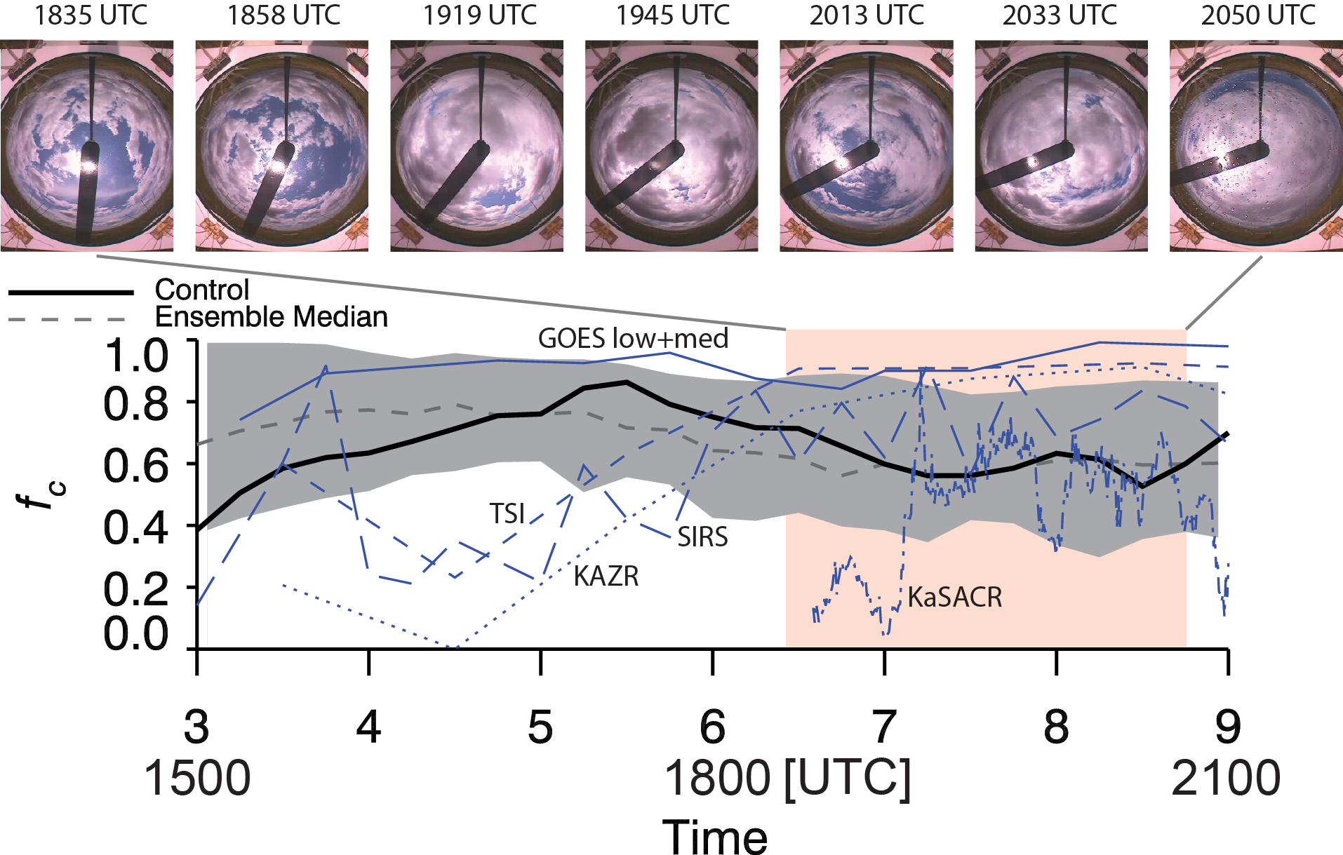
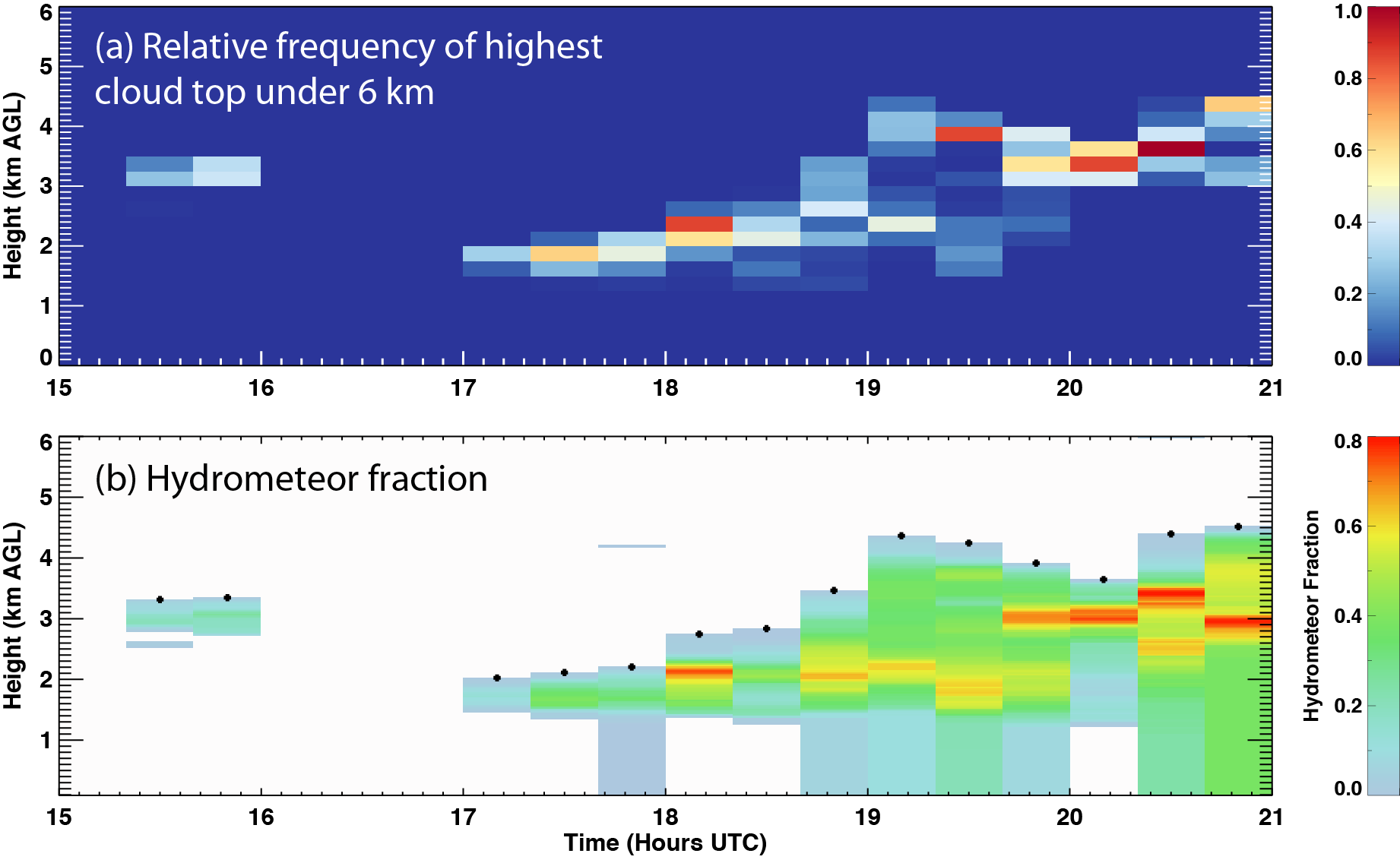
Investigated was the sensitivity of LES solutions to changes in spatial and temporal large-scale forcing for a challenging shallow cumulus and congestus event. The transient nature of the forcing (i.e., time-varying vs. steady-state) and its importance on simulation outcome is emphasized. This is accomplished by assessing the extent to which ensemble members reproduce salient observed macrophysical cloud-field properties over the ARM Facility. This study focused on a strongly forced case of shallow cumulus transitioning to precipitating cumulus congestus observed on 25 May 2011 during the DOE ARM and National Aeronautics and Space Administration (NASA) Global Precipitation Measurement (GPM) mission campaign, the Midlatitude Continental Convective Clouds Experiment (MC3E). Unlike typical idealized LES cases, the 25-May case exhibited substantial synoptic-scale variability and strong, height-dependent forcing. The cloud macroscale properties selected for this 25 May 2011 LES sensitivity study relied on the radar observations now routine for the ARM SGP. For simplicity, the comparisons are limited to four observational quantities when evaluating the LES ensemble solutions: cloud fraction, cloud-top distribution, areal precipitation fraction, and total precipitation.
Summary
LES solutions, with forcing, more closely matched to observations that captured several key aspects of the 25 May 2011 cloud event. The model captured, at least in a general sense, the transition from shallow cumulus to a multilayer cloud system that included deeper cumulus congestus. These results were encouraging, given the substantial synoptic variability and the highly idealized modeling framework. Results indicated that measurements obtained from scanning radar such as cloud-top height distributions better highlighted the differences across the Storm and Mesoscale Ensemble Experiment (SAMEX) simulations, compared to metrics obtained from profiling instruments. Multidimensional measures of cloud and precipitation geometry from scanning radar systems (e.g., precipitation onset, precipitation area, cloud-top PDFs) demonstrated several key advantages for the simulation driven with the time-varying forcing. Linking persistent biases in simulation results to differences in the scale of the forcing or bulk measures of forcing terms was difficult, suggesting that bulk representations of forcing quantities are insufficient in understanding cloud system evolution.