Memo from Real World to Cumulus Parameterizations: Get Organized!
Submitter:
Del Genio, Anthony D. — National Aeronautics and Space Administration
Area of research:
Cloud Processes
Journal Reference:
Science
Global climate models parameterize moist convection as a collection of individual convective cells that come and go over 15–30 minutes. Most of the world’s rainfall, however, is actually produced by “organized” storm systems: groups of storm clouds over an area comparable to a climate model gridbox that generate new storms as the old ones die out and that produce extensive thick high clouds that rain for many hours after the initial storms are gone. Because the models do not represent organized convection, their simulations are incorrect in three fundamental ways. First, the models rain over land in early afternoon rather than the late afternoon or evening, as observed. Second, parameterized convection heats mostly the middle troposphere, while observed organized storms heat the upper troposphere and cool the lower troposphere later in their life cycle, as localized convective rain gives way to extensive stratiform rain that evaporates below the melting level. As a result, large-scale waves that climate models generate in places where storms form may propagate to other regions incorrectly and affect weather in other parts of the world erroneously. Third, since long-lived organized convective systems are responsible for most of the world’s extreme rain events, climate model predictions of changes in precipitation extremes in a warmer climate cannot be viewed as physically realistic.
Impact
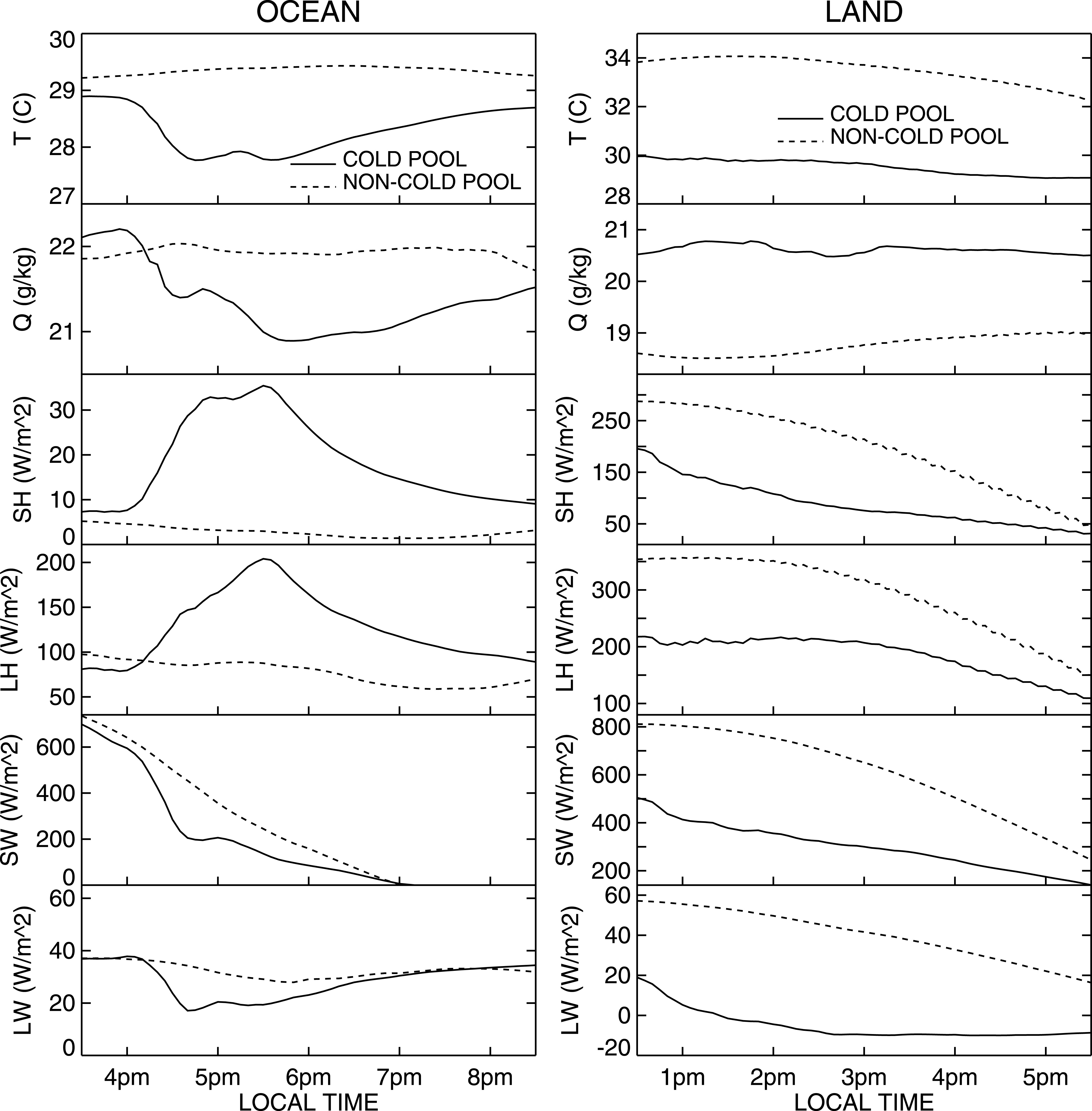
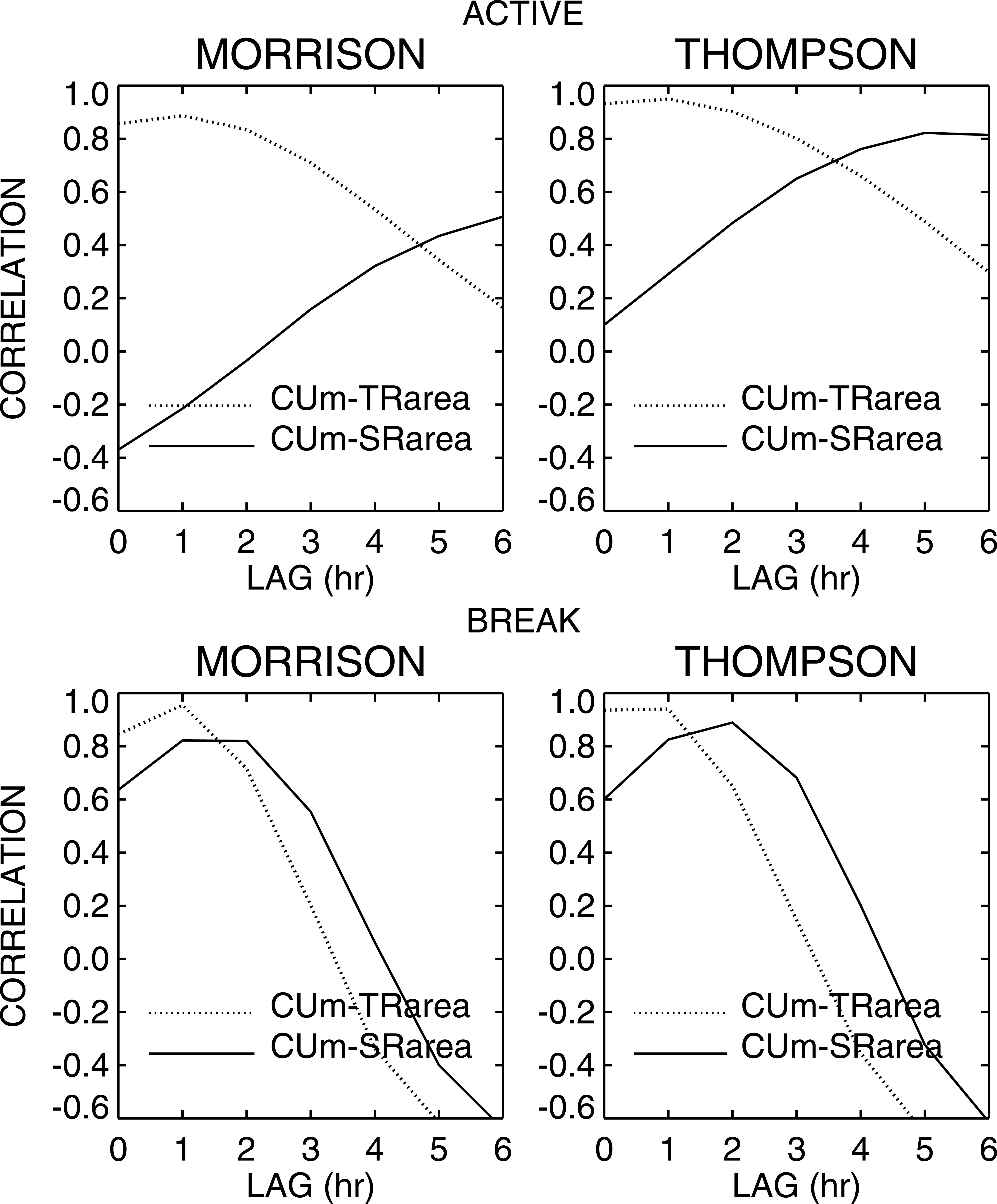
To represent organized convection, climate model parameterizations need to advance in two fundamental ways: (1) When model convective clouds produce cold downdrafts, they usually assume that the cold air mixes with warm air near the surface, which shuts off the convection; in the real world, downdraft “cold pools” remain distinct for some time and stimulate further convection by strongly lifting warm humid air where the cold and warm air meet. (2) When convection injects saturated air and ice into the upper troposphere, it can induce upward motions over large areas and further production and growth of ice crystals that allows stratiform rain to persist for hours; these upward motions are absent from most climate models. The 2006 ARM TWP-ICE campaign in Darwin, Australia, sampled convection in different meteorological situations and can provide guidance on how to approach parameterization of these two aspects of organized convection. ASR scientists used a cloud-resolving model that explicitly simulates the dynamics of convective storms to understand how convection responds to different TWP-ICE monsoon environments.
Summary
The simulations showed that cold pools lasted for a few hours regardless of whether the cold air was over land or ocean, but for different reasons. Over ocean, the warm sea surface gradually warmed the cold air through enhanced surface heat fluxes until it was no longer colder than the surrounding air. Over land, the cold air remained cold because clouds radiatively cooled the surface and suppressed surface heat fluxes, but the land surface outside the cold pool area gradually cooled to the same temperature as the sun set. In both ARM C-POL observations and the model, storms organized more extensively and lasted longer during the humid active phase of the monsoon than during the drier monsoon break period, despite the fact that wind shear, which is traditionally viewed as a necessary ingredient for organization, was weak. The biggest difference was that when the atmosphere was more humid, the stratiform rain region continued to grow and precipitate for hours after forming, while when the air was drier, it died out several hours after forming.