
Updated: Newly released data are now included from the Southern Great Plains, North Slope of Alaska, and Tropical Western Pacific atmospheric observatories from 2011 to 2013. Previous radar CFAD data (nsaradarcfadC1.c1) for the period between 2006 and 2010 from the North Slope observatory have been removed due to a radar calibration issue.
An ARM cloud radar simulator was developed to facilitate direct comparison of climate model output with the ARM ground-based cloud radar measurements by considering limitations and features of the observing process. As part of the effort, this global climate model-oriented ARM cloud radar data product, the Contoured Frequency by Altitude Diagram (CFAD), is produced to compare with the ARM radar simulator output.
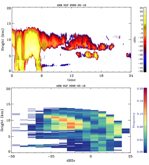
The measurement-based CFADs were generated from the ARM value-added cloud product, called Active Remotely-Sensed Cloud Locations (ARSCL), with quality controls and only include clouds detected by cloud radar. The reflectivity-height data were produced for every hour with the vertical resolution of 100 meters to capture both the diurnal variability and detailed vertical structures of clouds. The dBZ values are binned by each 5 dBZ in the range of -50 dBZ to 25 dBZ. The daily- and monthly-mean data can be easily calculated from the hourly data.
Each data file contains original radar reflectivity profiles interpolated into 100-m vertical resolution and hourly CFADs derived from best-estimate and clutter-removed radar reflectivity.
Data are currently available for the Southern Great Plains (SGP) atmospheric observatory, North Slope of Alaska, and Tropical Western Pacific observatory (Manus and Darwin) from 2011 to 2013. Each data file contains original radar reflectivity profiles interpolated into 100-meter vertical resolution and hourly CFADs derived from best-estimate and clutter-removed radar reflectivity.
Note that previous radar CFAD data (nsaradarcfadC1.c1) for the period between 2006 and 2010 at NSA have been removed due to radar calibration issues that affected the values of the radar reflectivity and therefore the derived CFAD. The CFAD data at NSA for this period will be updated once the calibration issues have been addressed.
Feedback and use of the data are welcomed and encouraged. For questions or to report data problems, please contact Yuying Zhang or Shaocheng Xie. To access the data set, please browse the ARM Data Archive. (Go here to create an account to download the data.)
# # #
The ARM Climate Research Facility is a national scientific user facility funded through the U.S. Department of Energy’s Office of Science. The ARM Facility is operated by nine Department of Energy national laboratories.