
Experiment seeks to elucidate impacts of unique polar clouds
On frigid nights, thin clouds spread their gossamer-like veil across thousands of kilometers in the Arctic. But, while they are typically invisible to the human eye, these clouds, called thin ice clouds (TIC) yield significant impacts: They suck water vapor from the atmosphere to exert a strong cooling effect and may initiate deadly winter storms as far as in the mid latitudes.
Currently, observations of these clouds are scarce and this paucity of data contributes to the large range of uncertainties in present-day and future simulations of the polar climates. To address this issue, with funding from the Canadian Space Agency (CSA), the Thin Ice Clouds in Far Infrared (IR) Experiment (TICFIRE) aims to develop a space-based instrument to measure the TIC and aerosol properties in the polar regions using the U.S. Department of Energy’s (DOE) Atmospheric Radiation Measurement (ARM) Climate Research Facility.
“Such an instrument would provide better input to the atmospheric models and also improve severe weather forecasting capabilities in the medium range,” said Jean-Pierre Blanchet, the lead investigator for TICFIRE at the University of Quebec at Montreal (UQAM). “Currently, we have the ability to forecast for about one week ahead and our forecast system tends to follow the observations rather than predict. We think we can extend that forecast and be more predictive during active winter and spring seasons.”
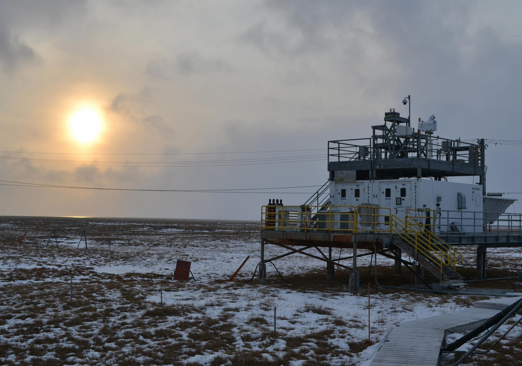
The TICFIRE scientists aim to deploy a ground-based version of the instrument at the ARM site in Barrow, Alaska. This location will offer the scientists the opportunity to investigate the impacts of aerosols on TIC formation and measure the radiative properties of the clouds.
Creating Diamond Dust
Clouds form when water vapor condenses into liquid water, or solid ice, onto tiny particles floating in the air. These tiny particles act as a nuclei for the condensation and freezing. For thin ice clouds, the tiny aerosol particles are typically influenced by pollution, which has circulated from lower latitudes towards the higher latitudes. Scientists have found, however, that when the aerosol particles are coated with acids, such as sulphuric acid, which is very abundant in pollution, water vapor doesn’t freeze very easily.

“The acid changes the property of the surface and inhibits the formation of ice,” Blanchet said. “That allows the supersaturation of the water vapor in the atmosphere to increase, even at very cold temperatures like minus 30°C, or minus 35°C.”
This effect produces a swollen “super-cooled droplet” and the supersaturation increases like “cranking a spring,” until eventually the droplet spontaneously freezes.
“It is like popcorn,” Blanchet said. “It is under pressure because supersaturation is 35 percent above saturation. So it just needs a few nuclei to start to grow spontaneously fewer but bigger crystals that can readily precipitate.”
Depending on acid pollution content, the process favors the formation of the thin ice clouds that cover large regions of the Arctic, which are so thin that they often appear transparent to the human eye. These clouds can consist either of many fine particles that don’t precipitate or of fewer large crystals that precipitate like “diamond dust.” These large formations twinkle like crystals when it is very cold, Blanchet said.
The higher the acid content in the Arctic pollution, the more clouds occur with big ice crystals and these large ice crystals deplete water vapor faster than pristine cloud formation does.
“As we remove the water vapor, it’s like the sky opening,” Blanchet said. “The greenhouse effects drop down very fast and that enhances the cooling of the lower atmosphere and the surface.”
Such fast regional cooling can strengthen the polar vortex that can shift toward the south during cold winters. The less water vapor in the atmosphere, the faster the vortex builds up, and these, in turn, drive winter storms.
Wintertime storms depend on the cooling rate of the polar region. “So if we cool the Arctic faster, we produce more storms and potentially stronger storms.” Blanchet said.
These storms are natural, but when increased pollution changes the cloud formation they become more frequent, and more powerful. In recent years several record storms have hit the U.S. and Canada. “So this is the chain of events that we want to explore,” Blanchet said.
A Small, but Mighty, Satellite
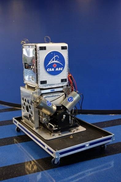
TICFIRE aims to explore this chain of events by improving the measurements of water-vapor concentration in the lower regions of the atmosphere and determining how the thin ice clouds contribute to atmospheric cooling. To do this, the scientists have developed a micro-satellite platform—about the size of a dishwasher—that can be launched in the early 2020s. The satellite is designed to measure cloud spectral properties in the in the Far Infrared (FIR) spectrum over cold geographical regions, where most of the atmospheric net thermal cooling takes place.
“The idea is to try to find the structure and types of those thin clouds,” Blanchet said. “And what we want to know is: How does, and when does, the precipitation start in very, very cold conditions?”
Due to technological limitations, conventional sensors do not monitor the far infrared spectrum resulting in a deficiency in key observational data. The goal of TICFIRE is to create the satellite that will fill this information gap. Two instruments are installed on the satellite: a multispectral Far IR Radiometer and an imager. The radiometer observes straight down—a Nadir view—and the imager takes measurements at an angle that skims the horizon of the planet—a Limb view.
“The lidar is a good instrument but it’s only giving us like a line of measurements,” Blanchet said. “It’s very narrow and what we want is to have coverage of both poles.”
By combining Nadir and Limb observations, and gaining full coverage, the mission aims to detect cold anomalies and the concentration of water vapor in the these regions, providing key data for severe storm forecasting and climate models.
“It’s very important to understand the water vapor and clouds processes appropriately so that the models can be initialized with the right data,” Blanchet said. “That is why we want to have a satellite to give us good measurements.”
# # #
The ARM Climate Research Facility is a national scientific user facility funded through the U.S. Department of Energy’s Office of Science. The ARM Facility is operated by nine Department of Energy national laboratories.