
Researchers investigate the polar atmosphere’s unique properties
On the north coast of Alaska, where the barren tundra meets the icy Arctic Ocean, Atmospheric Radiation Measurement (ARM) Climate Research Facility researchers are battling the elements to get a unique picture of the atmosphere in this rapidly changing region.
At this experimental site—Oliktok Point, which lies approximately 300 kilometers southeast of the fixed ARM site in Barrow, Alaska—scientists gather information about Arctic climate processes at the intersection between land and sea ice via ground instrumentation, unmanned aerial systems (UAS), and tethered balloons.
“There’s a difficulty in climate models in regard to resolving the actual properties of arctic clouds—really resolving how they behave in the atmosphere,” said Darielle Dexheimer, a scientist at Sandia National Laboratories, who is part of the Oliktok Point site operations team and oversees the tethered balloon systems (TBS). “So we are trying to get better data about how these clouds actually behave to help improve the models.”
Taking the Lab to the Science
A correct representation of clouds is not the only challenge for accurate climate modeling of the Arctic. Due to the remote nature and harsh conditions in the region, scientists also have difficulty gathering data on aerosols, the interactions between aerosols and clouds, and how both interact with the Earth’s surface.
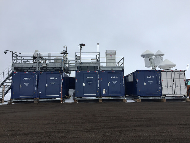
For this reason, the ARM Facility deployed the third ARM Mobile Facility (AMF3) to Oliktok Point in October 2013. The ARM mobile facilities sample essential atmospheric information in regions around the world that are important to the climate system, such as at Manacapuru in Brazil, or in the Ganges Valley in India.
“AMF3 was very different to previous mobile facilities in that it was designed ground up to be in the Arctic,” said Mark Ivey, the ARM North Slope of Alaska Facility Manager from Sandia National Laboratories. “We were thinking about what would withstand the full range of Arctic conditions and could remain in the Arctic for a long period of time.”
AMF3 houses a variety of instrumentation to collect an array of climate-related data about clouds, aerosols, and atmospheric radiation and will be deployed at the site for up to five years. Oliktok was already a unique site for scientists since the U.S. Department of Energy manages restricted air space in the region, which wasn’t permitted at the other Alaskan ARM sites of Barrow and Atqasuk.
“We have both long-term measurements on the ground that document the atmosphere over the entire annual cycle, as well as measurements that are performed using the balloons and aircraft,” said Gijs de Boer, a research scientist at the Cooperative Institute of Research in Environmental Sciences. “It’s a real advantage.”
Not Putting Too Fine a Point on it
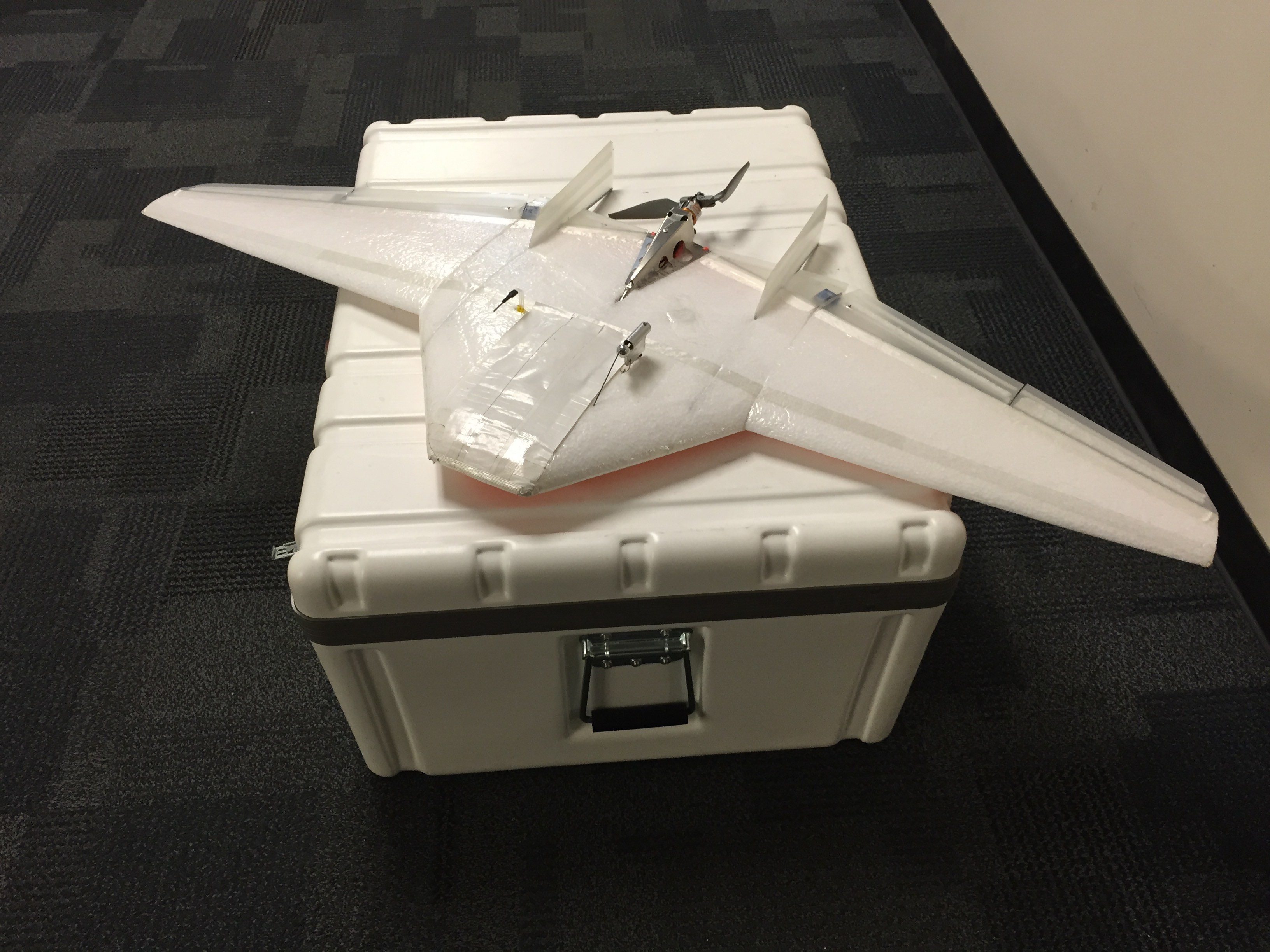
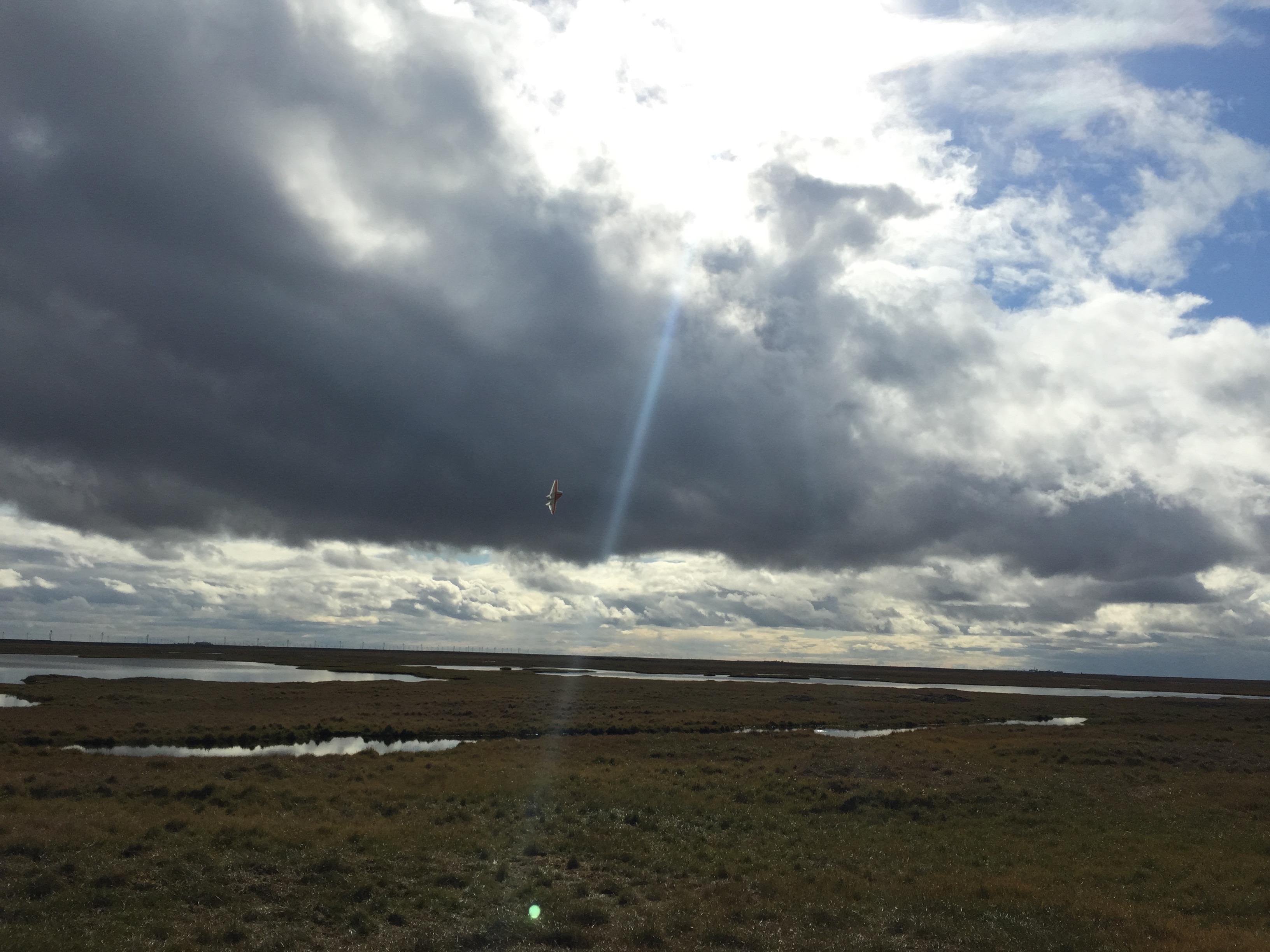
Where the land meets the sea in the Arctic is really a complex place, said de Boer. The water surface varies between sea ice and the ocean, and the land surface is frozen solid and snow covered for nine months of the year. To look at the variability of the temperature and moisture across these different surfaces, de Boer and his colleagues have flown at low altitudes for an hour at a time in a small, lightweight, unmanned aircraft called DataHawk 2, which was developed at the University of Colorado. Already these flights have revealed some interesting phenomena.
“We’ve been able to sample a transitional area where initially it was clear and then it became cloudy,” de Boer said. “So we were able to capture the evolution of that air mass as we transitioned between the clear and cloudy states.”
The advantage of using UAS to study the atmosphere is that they can capture regional data in a brief timescale. Climate models represent regions in space by grid boxes, and the data used to develop and evaluate the performance of those models typically comes from single-point measurements.
“But it’s oftentimes challenging to say how representative a single point is for a grid box average,” de Boer said.
To counteract that issue, the point measurement is often averaged over time, but during that time the atmosphere will be changing. UAS, however, can span a distance within a short timescale to provide more representative information.
“One thing these platforms have going for them is that they can provide some of the spatial variability that models require,” de Boer said.
Floating Through the Skies
Complementing the research performed by the UAS, ARM has also developed a TBS at Oliktok. The long-term goal is for the ARM Facility to perform routine TBS flights at the site to characterize the Arctic boundary layer under a range of conditions.
ARM is working to automate and “ruggedize” the TBS to the maximize extent. The long-term goal is to develop a system with a payload capacity in excess of 100 lbs that can autonomously collect data at high altitudes for several days while operating safely in the extreme conditions present in the Arctic. The TBS can then function as a sustainable baseline component of the ARM instrumentation at Oliktok Point and provide continuous, repeated measurements that have climatological value.
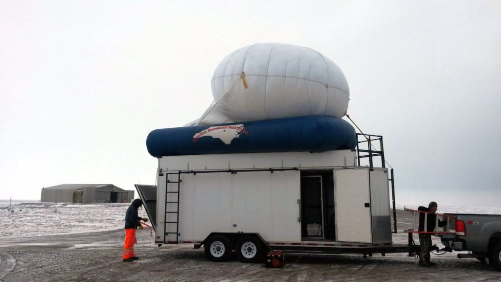
ARM scientists are currently conducting a series of campaigns to test the balloons and instrumentation and to define the operating conditions and sampling strategies for these routine flights. When the scientists are at the site, the balloons—which are about 22 feet in diameter—are launched daily and can remain aloft for up to 18 hours per day, with a long-term goal for the balloons to remain aloft continuously for multiple days. Attached to the tether are instruments and sensors that collect high vertical resolution atmospheric data at different levels from the surface up to 5000 feet.
“The big advantage of the balloons is that they can simultaneously collect data at various heights in the atmosphere for extended periods of time,” said Dexheimer. “We’re trying to get a higher vertical resolution measurement in the boundary layer because right now we don’t have a great grasp of how arctic clouds behave.”
In the October 2015 campaign, the team is planning to do “vertical soundings” with the balloons, where they raise and lower the balloons through the clouds to gather novel data, such as the temperature, relative humidity, wind speed, and pressure within the clouds themselves. “The balloons are really filling in a hole in the sense that you can get right inside the clouds,” Ivey said.
In the future, ARM plans to add aerosol and cloud instrumentation to the current meteorological instruments on the balloons. The ARM Facility has extensive experience with aerosol and cloud instrumentation with large manned aircraft like the G-1 used by the ARM Aerial Facility, Ivey said.
“Our challenge at the moment is to find low power, lightweight instruments that will give us similar measurements of aerosol properties and cloud properties and provide those measurements in the Arctic,” Ivey said. “There are exciting possibilities out there, including new work being funded through the DOE SBIR program. Within the next few years, we will be flying these systems and providing unique data sets to the scientific community.”
The combination of these atmospheric observations with measurements from both the ground and over the Arctic Ocean will give researchers a better sense of why the Arctic sea ice has been fluctuating in fairly dramatic fashion over recent years. These data will also be used to improve global climate models.
“It’s really exciting because it is meaningful work that will have an impact on how we understand climate and the rapid changes that are happening in the Arctic,” Dexheimer said.
# # #
The ARM Climate Research Facility is a national scientific user facility funded through the U.S. Department of Energy’s Office of Science. The ARM Facility is operated by nine Department of Energy national laboratories, including Sandia National Laboratories, which manages ARM’s activities at the Oliktok site.