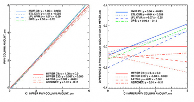
Wind Profiler Demonstration Network GPS (WPDNGPS)
Information updated on December 4, 2006, 7:59 pm GMT
General Data Description
The GPS-Met Observing Systems Branch of NOAA develops and assesses techniques to measure atmospheric water vapor using ground-based Global Positioning System (GPS) receivers. The branch was formed in response to the need for improved moisture observations to support weather forecasting, climate monitoring, and research. The primary goals of the branch are to demonstrate the major aspects of an operational GPS integrated precipitable water vapor (IPW) monitoring system, facilitate assessments of the impact of these data on weather forecasts, assist in the transition of these techniques to operational use, and encourage the use of GPS meteorology for atmospheric research and other applications.Note that these data were originally provided by NOAA's WPDN.
Data Stream Names
- 30wpdngps - Wind Profiler Demo Network (WPDN): total precipitable water vapor from GPS, 30 min
netCDF File Header Description (Data Object Design File)
Measurement Description
NOAA provides 30 minute averages of precipitable water vapor derived from
Global Positioning Systems (GPS) . On January 9, 1997, NOAA began processing
the data themselves; prior to that the data were processed by Scripps.
* Units of temperature were Kelvin before March 07, 2003.
** only appears in data beginning January 9, 1997.
*** only appears in data beginning December 9, 2001.
++ only appears in data beginning April 9, 2003.
- station name
- station number
- station latitude and longitude (degrees)
- station altitude (meters Above Mean Sea Level)
- water vapor (centimeters)
- pressure used for PWV calculations (millibars)
- temperature used for calculation (Centigrade*)
- total GPS signal delay (meters)
- dry component GPS signal delay (meters)
- wet component GPS signal delay (meters) **
- formal error (centimeters)
- relative humidity (percent)***
- Type of surface measurements++
* Units of temperature were Kelvin before March 07, 2003.
** only appears in data beginning January 9, 1997.
*** only appears in data beginning December 9, 2001.
++ only appears in data beginning April 9, 2003.
Temporal Coverage
Data begin on January 1, 1996.
Data Stream Inputs
sgp30wpdngpsX1.00
Notification Form Link
Related Links
Contacts
- ARM Mentor Laurie Gregory and
- ARM Software Developer Alice Cialella
Alice Cialella
Acronyms
| GPS | Global Positioning System |
| GSD | Global Systems Division |
| NOAA | National Oceanic and Atmospheric Administration |
| PWV | Precipitable Water Vapor |
| SGP | Southern Great Plains |
| WPDN | Wind Profiler Demonstration Network |


Expand All
Collapse All


