

“Change Is in the Air” as Scientists Evaluate Data Collection with Unmanned Aircraft
Published: 28 March 2016
Data gathered during ERASMUS are already available to compare with conventional data

For decades, studying Earth’s atmosphere meant gathering data with instruments based on land, lofted by balloons, or flown overhead in various types of aircraft, but change is “in the air” as increasingly popular unmanned aerial systems (UASs), such as lightweight miniature airplanes, prove useful for automating data collection.
Evaluating Routine Atmospheric Sounding Measurements Using Unmanned Systems (ERASMUS) is a U.S. Department of Energy (DOE)-funded campaign to collect a detailed data set and evaluate the potential for routinely collecting UAS data at the third Atmospheric Radiation Measurement (ARM) Mobile Facility (AMF3) at Oliktok Point, Alaska.
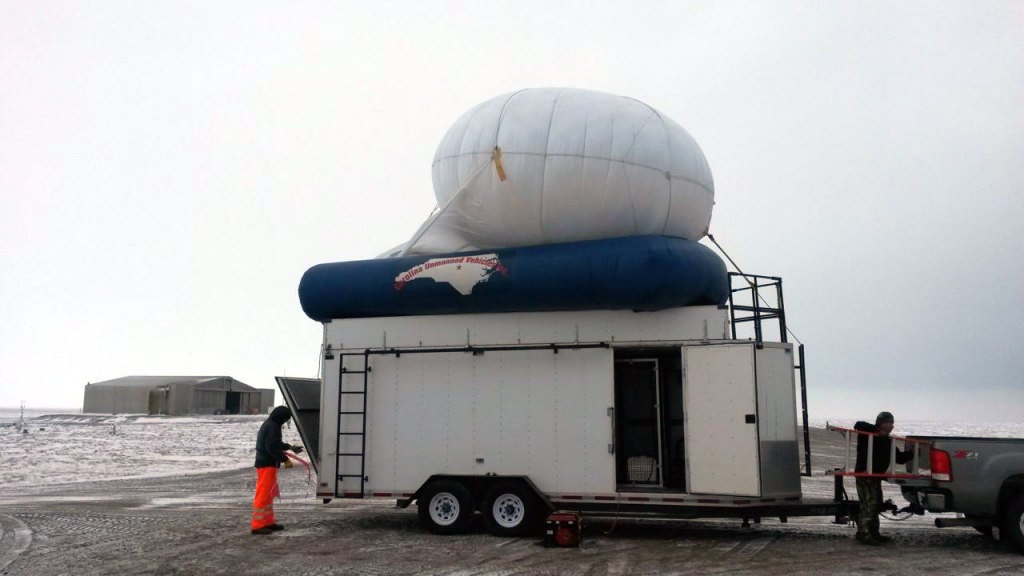
Data collected by UAS in DOE’s new Federal Aviation Administration (FAA)-approved airspace will complement information gleaned from existing ground instruments and tethered balloons that have also been in use at AMF3 at various altitudes for about a decade. Tethered balloons, including tethered sondes, provide a safe way to collect data inside clouds with potential mixed phases, such as icing. Additional UAS instrumentation will help scientists better understand aerosols, clouds, winds, and other weather-related characteristics in the lower Arctic.
UAS Data Already Available
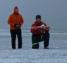
Data collected in August 2015 using small DataHawk UAS units developed at the University of Colorado-Boulder (CU) have already been uploaded to the ARM Data Archive and are available for comparison to other data collected conventionally, according to Gijs de Boer of CU’s Cooperative Institute for Research in Environmental Sciences (CIRES), who is lead scientist for ERASMUS.
“Information collected by DataHawks will help scientists gain insight into lower atmospheric thermodynamics and surface fluxes,” de Boer explains.
In April 2016, the DataHawks, as well as a Pilatus UAS are scheduled to fly in ARM’s FAA-approved airspace and gather additional data. Specific measurements for the DataHawks include temperature, humidity, pressure, and winds.
The Pilatus has a different set of instruments that also allow the study of aerosols and radiation. Similar to DataHawks, the midsize Pilatus aircraft measures temperature, humidity, pressure, and winds, but it is also capable of measuring aerosol size distribution and broadband long-wave and shortwave radiation because of its larger size.
Elaborating on the two-fold mission of the ERASMUS campaign, de Boer points out that the DataHawk and Pilatus will collect a new, unique data set that can be used for a variety of purposes, including process-level studies and surface-based sensor retrieval validation and evaluation. “This data set will also provide a first step toward evaluating current UAS technology as a useful tool for DOE ARM’s atmospheric science program,” de Boer adds.
Made from low-cost materials and selling for a total cost of about $1100, DataHawks are an attractive option for flight activities in high-risk environments, where operating larger UAS and manned aircraft presents a significant liability. The ERASMUS team is also using a Pilatus aircraft supplied by CU in order to demonstrate the ability of somewhat larger UAS platforms to provide high-quality radiation and aerosol measurements.
UAS Data Expected to have “Significant Impact” on Improving Modeling Tools
“I believe our ERASMUS UAS-based measurements and additional data collection by UAS in the future will have a substantial impact on improving modeling tools, as they can provide unique insight into the spatial variability of atmospheric and surface properties,” de Boer concludes. “A UAS can sample in the near-cloud and in-cloud environment and can reach low altitudes over difficult-to-sample areas such as the marginal ice zone at high latitudes.”
As lead author of “Unmanned Platforms Monitor the Arctic Atmosphere” in the American Geophysical Union’s Eos newsletter (22 February 2016), de Boer and others explained how UAS and tethered balloons are being used increasingly to improve the accuracy of numeric climate models in capturing the unique atmospheric dynamics of the Arctic.
Co-authors for the article are: Mark D. Ivey, Sandia National Laboratories, Albuquerque, New Mexico; Beat Schmid, Pacific Northwest National Laboratory, Richland, Washington; and Sally McFarlane and Rick Petty, Office of Science, U.S. Department of Energy, Washington, D. C.
# # #
The ARM Climate Research Facility is a national scientific user facility funded through the U.S. Department of Energy’s Office of Science. The ARM Facility is operated by nine Department of Energy national laboratories, including Sandia National Laboratories. Sandia manages the ARM North Slope of Alaska megasite, which includes Oliktok Point.
The ARM Climate Research Facility is a DOE Office of Science user facility. The ARM Facility is operated by nine DOE national laboratories, including .
Follow Us:


Keep up with the Atmospheric Observer
Updates on ARM news, events, and opportunities delivered to your inbox
ARM User Profile
ARM welcomes users from all institutions and nations. A free ARM user account is needed to access ARM data.


