
ARM experiment to characterize unique properties of clouds in the Southern Ocean
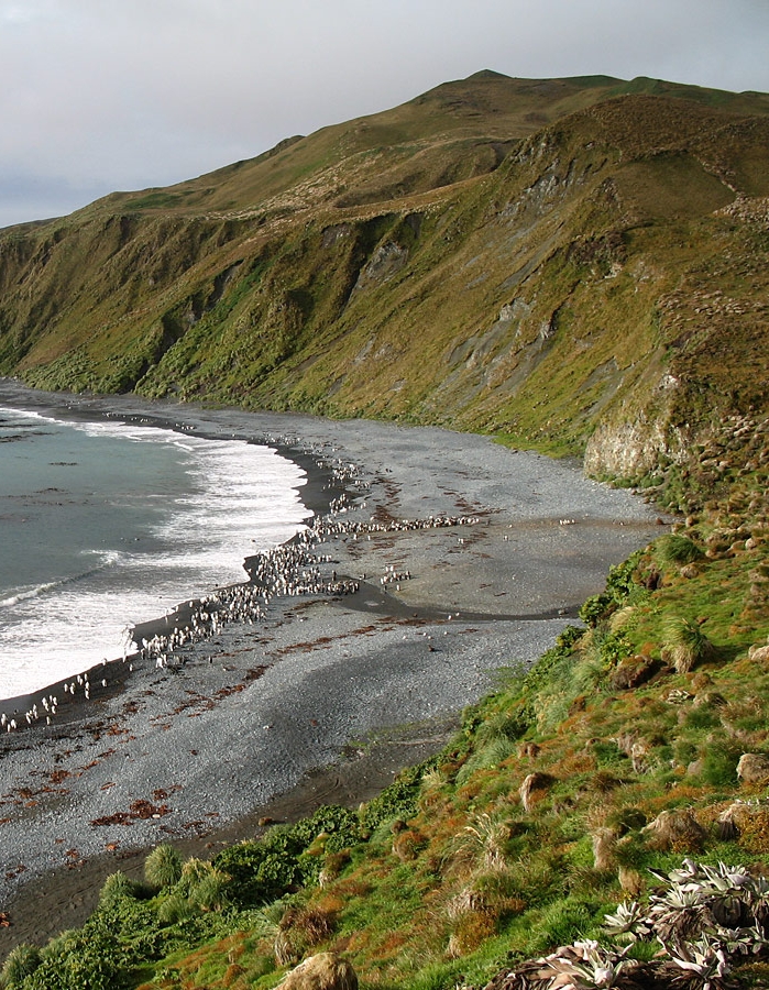
While penguins and seals are the main inhabitants of Macquarie Island, a remote grassy outcrop which lies about half-way between New Zealand and Antarctica, they will soon be joined by a suite of instruments from the U.S. Department of Energy’s (DOE) Atmospheric Radiation Measurement (ARM) Climate Research Facility. These instruments will measure surface radiative fluxes and cloud and aerosol properties at this locale for two years providing vital information for climate scientists and meteorologists.
“Clouds over the Southern Ocean are poorly represented in current models and we want to understand why that is,” said Roger Marchand from the University of Washington, lead scientist of the Macquarie Island Cloud and Radiation Experiment (MICRE). “In particular, we need to understand characteristics such as, how much water is in the cloud, and how big the particles are.”
The ARM instruments will be housed at a permanently manned research station on the island, which is operated by the Australian Antarctic Division (AAD). The experiment will be conducted in coordination with AAD and the Australian Bureau of Meteorology activities planned at this site, which include using radar and lidar to measure critical properties of clouds and aerosols.
An Absence of Ice
Currently, scientists knowledge of the properties of clouds over the Southern Ocean is limited, leading to a poor representation of the contribution of such clouds in climate models.
“In a broad sense, we’ve learned over the last decade that it’s uncertainty or inability to predict low cloud properties well that limits our ability to predict how much warmer it’s going to get in the future,” Marchand said.
 This is especially true for clouds in the Southern Ocean, where scientists have relied heavily on satellite data sets for a quantification of cloud and aerosol properties. Large uncertainties exist, however, for the satellite data in this region. “So it’s these clouds in particular that we need to better understand, yet this region is also one that’s hard to get to and measurements have been sparse,” Marchand explained.
But it is not just location that may have made the uncertainties associated with cloud properties in this region significant, Marchand said. Scientists believe that the clouds themselves over the Southern Ocean may be unique. Researchers know that these clouds contain much larger quantities of supercooled liquid water than clouds over the northern hemisphere.
“We suspect that this is due to factors such as reduction in the particles that help form ice in the atmosphere, so-called ice nuclei,” Marchand said. “But we don’t really know that for sure.”
Consequently, the scientists are also measuring aerosol properties in the region, as aerosols can act as ice nuclei. The Southern Ocean is remote from most continental and man-made aerosols, a fact that can have a significant impact on cloud properties and ice properties, Marchand said. “So cloud aerosol interactions are at the heart of our uncertainties in being able to predict changes in cloud cover in the future,” Marchand said.
In addition, scientists will aim to characterize the uncertainties associated with satellite data in the region. “Our goals are both to directly observe, but also to help understand, the limitations of current satellite data sets,” Marchand said.
A Spectrum of Measurements
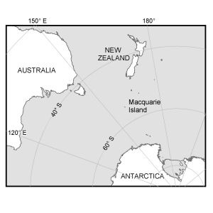
Once scientists had identified the need for additional measurements of cloud properties in the region, the quest became to find the ideal location for ground-based instruments, in a region that is mostly covered by ocean. Macquarie Island, located far south at 54.61o S, 158.87o E, proved the ideal site for the instruments.
“Satellite data shows a significant north-south gradient in cloud properties and this island is well situated to observe changes as fronts and other disturbances sweep by the region,” Marchand said.

At the manned research station, a spectrum of instruments including a ceilometer and multiple radiometers will be deployed to measure how much light in the visible or infrared wavelengths is coming to the surface, in order to infer information about the cloud and aerosol particles. The ARM instrumentation will be installed March 2016 and will be stationed on the island for two years so that the scientists can obtain a picture of the full seasonal cycle of cloud and aerosol properties, and how much these properties vary.
“This experiment is really about trying to understand the physical processes through which clouds and aerosols are interacting so that we can represent these processes more accurately in models.”
# # #
The ARM Climate Research Facility is a national scientific user facility funded through the U.S. Department of Energy’s Office of Science. The ARM Facility is operated by nine Department of Energy national laboratories.