
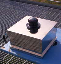
Imaging technologies help scientists correlate and compare data retrieved by sensors and lasers against visual data. One such technology used by ARM researchers is a Total Sky Imager (TSI), which provides real-time processing and full-color display of daytime sky conditions. However, to get the continuous picture of cloud life cycles needed for critical scientific analysis, a night-time visual technology was needed. In July 2006, a new Infrared Sky Imager system was installed at the ARM Southern Great Plains (SGP) site. This new system captures full hemisphere (180-degree field-of-view) infrared images of the sky during both the day and night. These images can be used to calculate the fraction of clear sky or the percentage of cloud cover. The addition of a nighttime cloud fraction measurement fills a major data void (continuous, accurate measurements of hemispheric cloud coverage) for ARM researchers.
The Infrared Sky Imager operates at thermal wavelengths (the infrared range from 8 to 14 microns), using high-speed precision optics to form images of low- and mid-altitude clouds. These images are captured by a thermal infrared detector. Unlike classical cooled infrared sensors, the detector operates at room temperature and does not need a cryogenic cooling system, making the system inherently reliable and maintenance free. To improve signal to noise ratio, discreet images can be combined within the sensor electronics before being passed to the remote computer. The instrument software automatically identifies cloudy and clear regions, and calculates the percentage of cloud cover that affects downwelling longwave radiation measurements at the surface.
During development of the system, an additional user-definable field-of-view retrieval centered on zenith (90 degrees from the horizon) was incorporated into the processing software. This capability relates directly to the same user-definable “zenith circle” retrievals of the TSI. The user can also perform geometric calibrations to produce orthographically projected images. Using orthographic projection, the user can make a direct comparison with satellite images and human observations.
Now that the new system is deployed, a thorough operational testing and evaluation period will take place. This will allow ARM operations personnel to understand the reliability and maintenance requirements of the system, as well the characteristics of the data product through comparison of cloud fraction results with those of other systems (such as the TSI). Depending on the technical performance of the Infrared Sky Imager, additional systems may be deployed to all the ARM sites.