
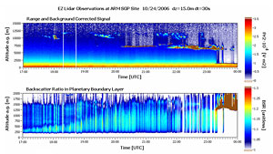
Scientists routinely use light detection and ranging (lidar) systems to obtain data about cloud and aerosol layering and optical properties. In October 2006, ARM scientists spent a week at the ARM Southern Great Plains (SGP) site using the established Micropulse Lidar (MPL) and a new EZ Lidar to gather measurements of aerosols and cloud structure captured in both signals. Evaluation of the EZ Lidar performance by direct comparison with MPL data at the SGP Central Facility will allow scientists to validate the EZ Lidar as a new tool for automated retrievals of aerosol and cloud measurements.
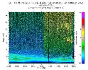
The EZ Lidar from Leosphere is a compact, robust, turn-key and eye-safe system developed to provides atmospheric researchers, operational meteorological networks and pollution agencies a standardized tool which can be easily integrated on an all-weather remote sensing platform. During simultaneous observations at the SGP Central Facility on October 24, 2006, data comparison from the two of the post-processed MPL retrievals and the automatically obtained EZ Lidar retrievals show the ability of the latter system to detect cloud structures from the range corrected profiles and to quantify the aerosol loads in boundary layer from the backscatter ratio profiles (see figures).
The large collection of instruments at the SGP is ideally suited for this study from another aspect. The EZ Lidar real-time software provides not only the lidar signal acquisition, but also retrievals of backscatter and extinction coefficient profiles, backscatter ratio profiles, optical depth, boundary layer and cloud heights, etc. Because of the limitations inherent in sophisticated and automated retrieval schemes, it is important to define and quantify their accuracy. A wide variety of SGP instruments will be used to evaluate various aspects of the EZ Lidar performance, contributing valuable input for decision making on further hardware and software improvements to reduce uncertainty in the lidar results.