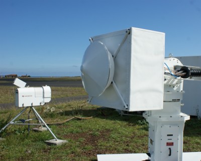
As a prelude to great things to come throughout the user facility, a new 95-gigahertz scanning W-band cloud radar was installed in late September at the ARM Mobile Facility deployment site in the Azores. This new radar joins the instrument suite that has been collecting data at the airport on Graciosa Island since May 2009. The added scanning capability provides 3D information about clouds that scientists need to improve climate models. The new scanning radar will remain on Graciosa until early December for side-by-side operations with the mobile facility’s baseline W-band cloud radar.

The term “W-band” refers to the frequency range of the radar signal at around 75 to 110 gigahertz. Following a recommendation by the scientific user community, the scanning capability was added to the existing W-band cloud radar operating at the Southern Great Plains site. This required several modifications to the existing software to account for the scanning parameters, data bandwidth impacts, and modified data ingest. From an operational perspective, the change required a new environmental enclosure and a new mount on an “elevation-over-azimuth” positioner. This positioner includes mechanisms that move the antenna up or down (elevation) and around in circles (azimuth). The radar will maintain its calibration by “looking” at a calibration target mounted on a 19-meter tower located approximately 1 kilometer from the radar.
The deployment in the Azores represents an important operational test period for the new radar, as 18 more scanning radars are being developed through funding from the American Recovery and Reinvestment Act. Almost half of the $60 million in Recovery Act funds allocated to the ARCF are being spent on new radars, which will be deployed throughout the user facility sites. Some of the radars will combine multiple frequencies on a single positioner, increasing the radar’s functionality in measuring the physical structure of clouds.

