

New Radar Facilities for Remote Areas
Published: 13 September 2015
Next generation technology and deployments around the globe will fill in data gaps

For the first time, state-of-the-art cloud radars are headed to West Antarctica—along with the expertise of ARM engineers—to collect cloud and precipitation data for the ARM West Antarctic Radiation Experiment, known as AWARE. New radar facilities in Alaska and the Azores, two other locations with unique weather patterns, will also help scientists collect data to evaluate and refine existing climate models.
“This is very ambitious,” said Nitin Bharadwaj, the ARM radar engineering and operations group lead at Pacific Northwest National Laboratory (PNNL). “We’re not just trying to get the best data for scientists, we’re going to get it from really remote places.”
The ARM Climate Research Facility, a U.S. Department of Energy scientific user facility, currently operates a network of 33 radars located around the world. With frequencies ranging from about 5 to 95 GHz, these instruments capture information about cloud occurrence and morphology—the phase (liquid or ice), size, and shape—classify hydrometeors and the air motions in them, which enable researchers to better understand clouds and precipitation. Ultimately, by augmenting the radar data with additional information from other sensors, scientists can construct a more holistic understanding of the water cycle.
“In some of the locations ARM deploys, no previous observations are available. Thus, the added value is significant,” said Pavlos Kollias, leader of the radar science group and professor in the Department of Atmospheric and Oceanic Sciences at McGill University in Canada. “So once we have captured fundamental properties of clouds from an annual cycle, we want to know how well numerical models at various scales benchmarked themselves against the ARM observations.”
On the Edge
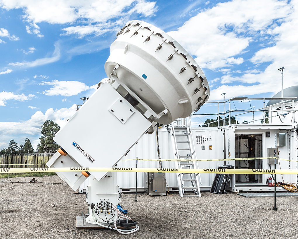
The radar equipment headed for West Antarctica was beta tested last month in Colorado with Andrei Lindenmaier at PNNL, one of four ARM radar mentors, and the Los Alamos National Laboratory (LANL) team who is managing the AWARE campaign. He’ll join the instruments at McMurdo Station and set them up for a 14-month campaign to collect the most sophisticated cloud measurements data taken from the melting edge of climate change. Although Lindenmaier has worked with radar systems in other cold climates (the High Arctic), this will be his first time adapting to the extreme weather of West Antarctica.
In addition to modifications that keep the cloud radars functioning in 150 mph winds or sub-50ºF temperatures, Lindenmaier noted that data transmission will be slow through the internet; it will not happen in real time. Due to the large data volumes expected from these sophisticated radars and the limited communications bandwidth from Antarctica, information has to be stored locally, and then relayed back to the ARM data systems, so there will be a few months’ delay before all the measurements become available to researchers in the ARM Data Archive.
At the opposite pole, Oliktok Point on the North Slope of Alaska, more than two dozen instruments already operate at ARM’s third Mobile Facility (AMF3) managed by Sandia National Laboratories with support from Todd Houchens, a radar technician. However, new instruments, which include Ka– and W-band scanning cloud radar, precipitation radar, and Doppler lidar, will help scientists better study the area’s mixed phase clouds.

With second generation equipment, researchers can discern the finer details of atmospheric signals taken from 30 meters to 17 kilometers above the ground, said Bradley Isom, a PNNL engineer and radar mentor. For example, the vertically pointing Ka ARM Zenith Radar (KAZR) improves cloud sampling capabilities with pulse compression, toggling between two successive operational modes to parse signals from heavy rain from those of cloud structures. This engineering provides cloud resolution down to 30 meters, yet still maintains enough sensitivity to see to the edge of clouds, allowing scientists to identify what lies between the surface and the top of atmosphere. More accurately measuring cloud properties will improve understanding of how clouds are impacting the surface and atmospheric energy budgets.
There’s no shortage of engineering challenges with radar, from troubleshooting maintenance of the motors on scanning radars to creating algorithms that translate digital signals into user products, noted Isom. Moreover, the systems designed to work during Oliktok’s sub-zero winters often overheat when temperatures rise to 70ºF in the summer.
Marine Clouds
In the more consistently temperate Eastern North Atlantic facility in the Azores islands, researchers already have baseline data about the low stratiform cloud systems that characterize the subtropical ocean region, collected during the 2009-2010 Clouds, Aerosol, and Precipitation in the Marine Boundary Layer field research campaign. Most of the instruments on Graciosa Island are identical to those designed for Oliktok, said Bharadwaj.
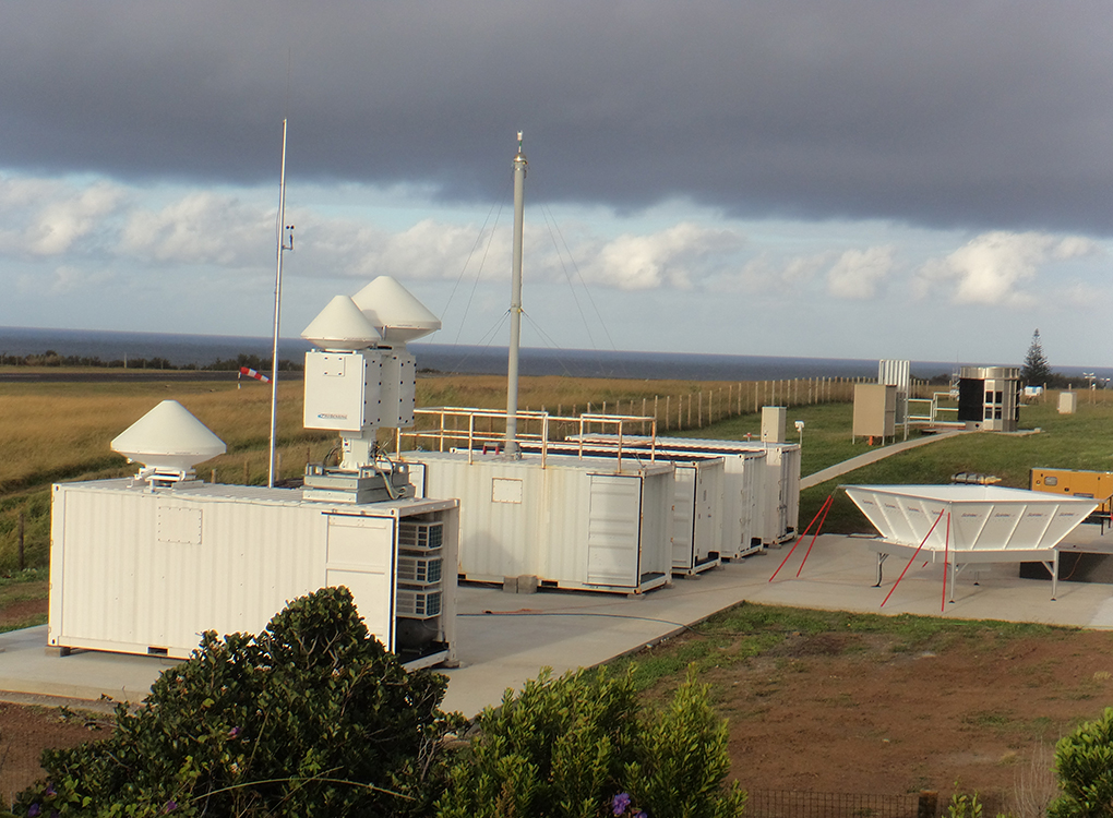
The questions in the Azores are not so much about what cloud systems we expect to observe; it is what controls their amount that is not well understood, explained Kollias. It’s more about the “inner works” of clouds themselves: How aerosols affect the propensity of clouds to precipitate; what determines if these low-level clouds will break up; or how dry air gets into the clouds to effectively make them evaporate. With answers to questions like these, scientists can better account for the response of marine clouds to increasing levels of greenhouse gases. For each of these new radar systems, the two most important things are operational stability—getting the instruments to provide continuous, high-quality observations—and then obtaining progressively more detailed information to get at the next levels of cloud complexity.
Josh Snider, a radar technologist from LANL, supports the radars at the ENA site, as well as those that travel with the ARM mobile facilities.
“We need to continue to push forward the radar technology and go after new deployments [of radar] because there are gaps in the information we need,” Kollias said. “Ultimately, we want our radar facilities to see the smallest clouds and, at the same time, the convective clouds that make thunderstorms and tornadoes. We try to do things that nobody else has ever done.”
# # #
The ARM Climate Research Facility is a national scientific user facility funded through the U.S. Department of Energy’s Office of Science. The ARM Facility is operated by nine Department of Energy national laboratories, including the Pacific Northwest National Laboratory, which manages ARM’s radar facilities.
The ARM Climate Research Facility is a DOE Office of Science user facility. The ARM Facility is operated by nine DOE national laboratories, including .
Follow Us:


Keep up with the Atmospheric Observer
Updates on ARM news, events, and opportunities delivered to your inbox
ARM User Profile
ARM welcomes users from all institutions and nations. A free ARM user account is needed to access ARM data.


