

Satellite Data Conversion Supports Tropical Cloud Research
Published: 31 August 2004
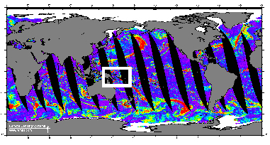
For several years, the ARM Program has collected global satellite data for wind speed, precipitable water vapor, cloud liquid water, and rain rate over the ocean. From ascending and descending satellite passes, these data represent atmospheric state information that is useful for driving and diagnosing climate models, particularly in the tropics. The data sets, produced twice a day by Remote Sensing Systems (RSS), come from Special Sensor Microwave/Imagers (SSM/I) on board satellites involved in the U.S. Air Force’s Defense Meteorological Satellites Program. The ARM Climate Research Facility data systems staff recently completed a major effort in reviewing the needs for this data and converting it to NetCDF (network common data format) with associated image files for enhanced usability.
In 2002, RSS updated the algorithm used to produce the SSM/I data sets, followed soon thereafter by a reprocessing of all data from 1996. The ARM Climate Research Facility data systems staff used this opportunity to review ARM science needs and make any desired enhancements their SSM/I data collection script prior to replacing the associated data in the Archive. Two science needs became apparent: ARM trajectory work to determine tropical cirrus cloud origins, and rainfall measurements in the tropics. By increasing the longitudinal and latitudinal boundaries by 15 degrees, the expanded data would include much of the equatorial Indian Ocean, providing a broader frame of reference for research at the ARM Climate Research Facility Tropical Western Pacific locale. To enhance user friendliness of the information, the satellite data were converted to NetCDF format. Quantities derived from the SSM/I data, including precipitable water vapor, are stored as a function of local equatorial crossing time (time of satellite overpass), latitude, and longitude. The data sets now also include thumbnail and full resolution images as rendered by the SSM/I.
With the conversion of the expanded satellite sensor data to NetCDF files complete, the new preprocessed data from 1996-01-01 through 2004-06-30 is now available from the Data Archive. The SSM/I data will be processed monthly on a 2-month delay, to allow time for sensor drift corrections to pre-applied by RSS.
The ARM Climate Research Facility is a DOE Office of Science user facility. The ARM Facility is operated by nine DOE national laboratories, including .
Follow Us:


Keep up with the Atmospheric Observer
Updates on ARM news, events, and opportunities delivered to your inbox
ARM User Profile
ARM welcomes users from all institutions and nations. A free ARM user account is needed to access ARM data.


