
SuomiNet is an international network of global positioning system (GPS) receivers, configured and managed to generate near real-time estimates of precipitable water vapor in the atmosphere, total electron content in the ionosphere, and other meteorological and geodetic information. Last fall, scientific collaborators at the National Oceanic and Atmospheric Administration (NOAA) Forecast Systems Laboratory* identified a time-delay in the availability of SuomiNet data from the ARM Climate Research Facility’s Southern Great Plains (SGP) site in Oklahoma. This delay was impacting short-range weather forecasts used by the National Weather Service’s Storm Prediction Center in Norman, Oklahoma. Data from the SGP Extended Facilities was being collected in half-hour increments and delivered about 15 minutes later to the SuomiNet data repository. In contrast, SuomiNet data collected by other organizations in the region were being delivered 3 to 5 minutes after the same half-hour collection increment. Because the SGP hosts a large concentration of GPS receivers-15 to be exact-dedicated to atmospheric research, this lag in data availability created a major gap in regional coverage.
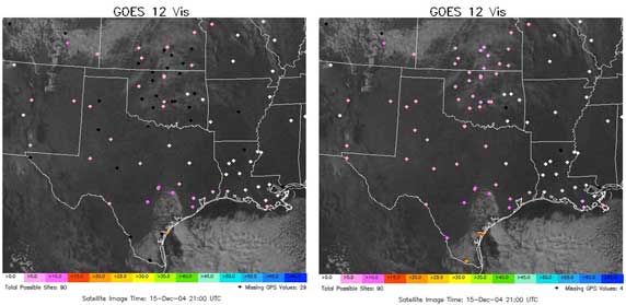
Recently completed communication upgrades now deliver SuomiNet data from the SGP Extended Facilities to an ftp server at the SGP Central Facility within 1 to 2 minutes from collection. These data are then automatically picked up by NOAA through a routine acquisition process. By improving the data delivery system of the SGP SuomiNet installations, ARM Climate Research Facility data can now be included in the Forecast Systems Laboratory’s weather forecast model and will improve their ability to accurately forecast severe storms in the region.
Since 1993, NOAA’s Forecast Systems Laboratory, other government agencies, and universities have relied on SGP facilities and resources to help develop ground based GPS water vapor observing systems. They also use the site to perform data intercomparisons in assessing the systems’ characteristics and evaluating their suitability for climate research and observing system (primarily radiosonde and satellite) calibration and validation.
*Forecast Systems Laboratory was merged with other labs in 2005 into Earth System Research Laboratory.