

Infrared Thermometers Complete Cloud Pictures
Published: 15 April 2005
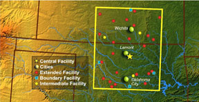
To help ARM scientists analyze cloud temperatures and infer cloud heights over the ARM Climate Research Facility Southern Great Plains (SGP) site, operations staff are installing six new infrared thermometers (IRTs) at Extended Facilities throughout the domain, with plans to eventually equip all Extended Facilities. One of the primary uses of these data is to test and combine with satellite data. While satellite data affords good spatial coverage across the area, it only provides a “snapshot” every half hour, and has known weaknesses, especially in inferring such quantities as low cloud base heights, low cloud amounts, and detection of few or smaller clouds. Having the additional IRT retrieval points for comparison and testing will allow the ARM science team to refine the retrievals by cloud situation.
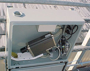
New features for the IRT include a mirror surface hardened with a thin coating of silicone dioxide, and a prototype automatic mirror washing/drying system to keep the IRT mirror surfaces clean and free of dew or frost, thereby providing more accurate measurements of sky brightness temperature. To evaluate the cleaning system and study the freezing characteristics of the cleaning fluid, sample systems were tested during the winter months on the elevated instrument platform of the SGP Guest Instrument Facility. In addition, a new data acquisition and display system developed by ARM personnel is capable of logging the IRT serial data at a minimum of 5Hz. This system was tested for compatibility with the Linux© computers like those at the SGP Extended Facilities, as well as with the Windows© operating systems planned for installation at the ARM Climate Research Facility Tropical Western Pacific and North Slope of Alaska locales.
Members of the ARM science team will take the satellite “snapshots” and compare to the IRT cloud retrievals, then use the satellite data to help interpolate and analyze the SGP domain. By using surface and satellite data, ARM researchers can “paint a more complete picture” of both temporal and spatial resolution. One application of these data is in support of the Broadband Heating Rate Profile (BBHRP) project, a comprehensive effort by the ARM science team to provide a critical tool for evaluation of radiation measurements, radiative transfer models, and the specification of the relevant atmospheric properties, with a key focus on clouds. The spatial variability of clouds across the SGP site must be included for the BBHRP to provide a realistic estimate of heating rates for the SGP area as simulated by single column models.
The ARM Climate Research Facility is a DOE Office of Science user facility. The ARM Facility is operated by nine DOE national laboratories, including .
Follow Us:


Keep up with the Atmospheric Observer
Updates on ARM news, events, and opportunities delivered to your inbox
ARM User Profile
ARM welcomes users from all institutions and nations. A free ARM user account is needed to access ARM data.


