
To facilitate the direct comparison of climate model outputs with its ground-based radar and lidar measurements, the Atmospheric Radiation Measurement (ARM) user facility provides joint histograms of the frequency distribution of radar reflectivity and lidar scattering ratio at each height. Scientists can also compare these joint histograms, also called contoured frequency altitude diagrams (CFADs), with outputs from radar and lidar simulators such as the Earth Model Column Collaboratory (EMC2) and version 2 of the Cloud Feedbacks Model Intercomparison Project (CFMIP) Observation Simulator Package (COSP2.0).
ARM has released a reprocessed CFAD product from the Ka-Band ARM Zenith Radar (KAZR) and a new CFAD product from the high-spectral-resolution lidar (HSRL).
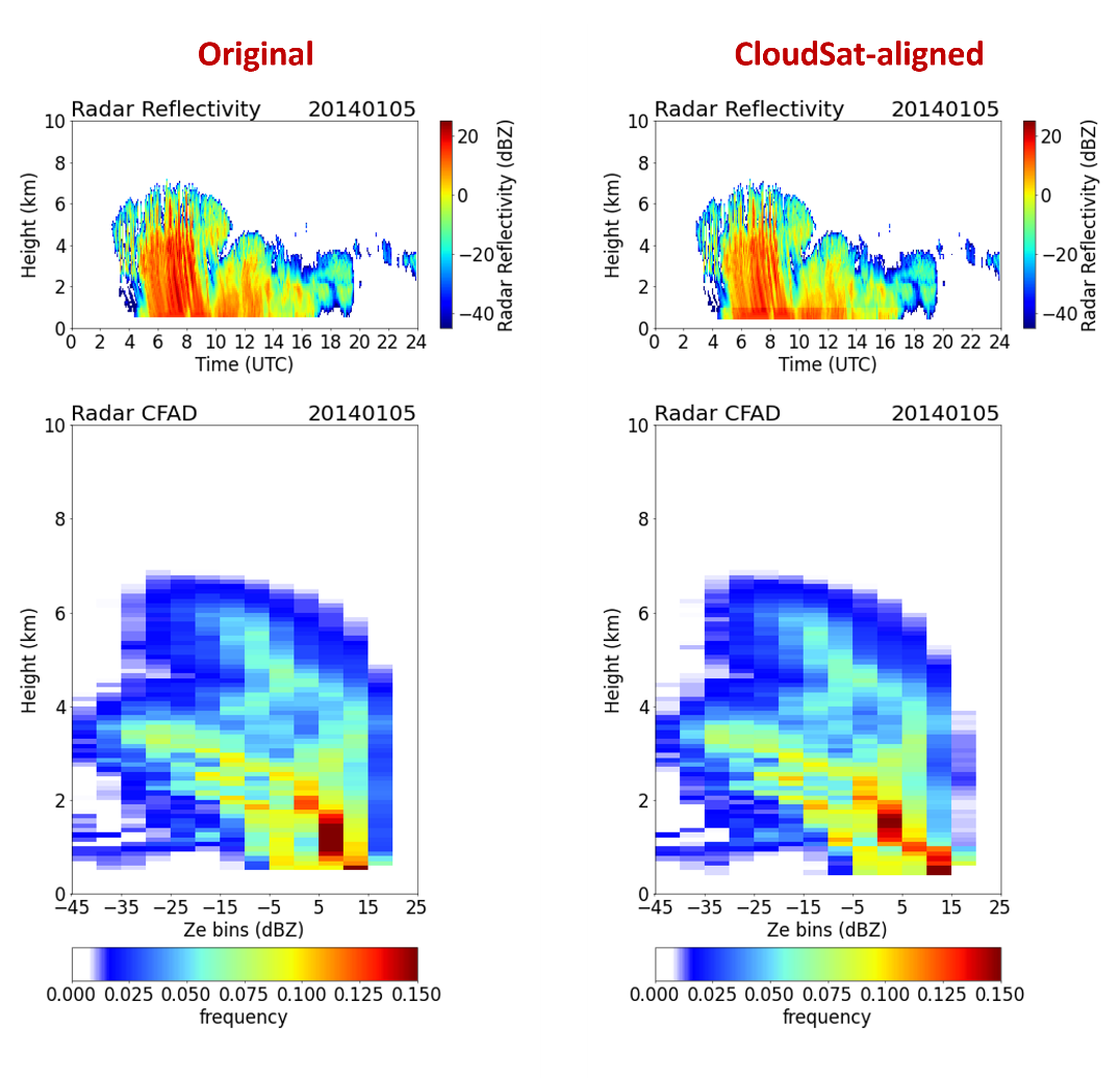
The KAZR product, known as KAZRCFAD, contains vertically regridded best-estimate radar reflectivity and joint histograms of the best-estimate reflectivity and height up to 20,000 meters. Instead of using best-estimate reflectivity from the KAZR Active Remote Sensing of CLouds (KAZRARSCL) product, the reprocessed product was generated using CloudSat-aligned best-estimate reflectivity from the KAZRARSCL-CloudSat Calibration (KAZRARSCL-CLOUDSAT) product.
Reprocessed KAZRCFAD data are available for the following ARM sites and periods:
- the Southern Great Plains atmospheric observatory from March 1, 2012, to August 31, 2017
- Oliktok Point, Alaska, from November 1, 2015, to November 29, 2017
- the North Slope of Alaska atmospheric observatory during March 1, 2012, to June 30, 2017
- McMurdo Station, Antarctica, from April 1 to December 31, 2016, during the ARM West Antarctic Radiation Experiment (AWARE).
The temporal and vertical resolutions of the best-estimate radar reflectivity in KAZRCFAD are 4 seconds and 100 meters. The dBZ values are binned by each 5 dB in the range of minus 50 dBZ to 25 dBZ.
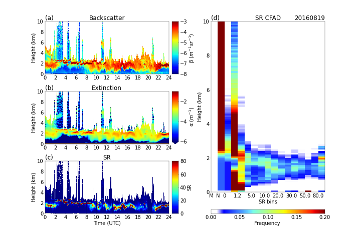
The HSRL product, known as HSRLCFAD, contains vertically regridded lidar scattering ratio and joint histograms of the scattering ratio and height up to 20,000 meters, and it is generated using HSRL measurements.
HSRLCFAD is available for the AWARE McMurdo Station site from November 29, 2015, to January 2, 2017.
For both KAZRCFAD and HSRLCFAD, the joint histograms are created for every hour with a 100-meter vertical resolution to capture both the diurnal variability of clouds and their fine vertical structures.
Scientists can use the KAZRCFAD and HSRLCFAD data sets now. Find more information about the CFAD products on this web page or in Zhang et al. (2018).
Feedback and use of the data are always welcomed. If you have questions/suggestions, please contact ARM translator Shaocheng Xie or developers Yuying Zhang or Jingjing Tian.
Users can access the KAZRCFAD and HSRLCFAD data from the ARM Data Center. (To download the data, first create an ARM account.)
To cite the data, please use doi:10.5439/1876547 for KAZRCFAD and doi:10.5439/1975861 for HSRLCFAD.
Reference: Zhang Y, S Xie, S Klein, R Marchand, P Kollias, E Clothiaux, W Lin, K Johnson, D Swales, A Bodas-Salcedo, S Tang, J Haynes, S Collis, M Jensen, N Bharadwaj, J Hardin, and B Isom. 2018. “The ARM Cloud Radar Simulator for Global Climate Models: A New Tool for Bridging Field Data and Climate Models.” Bulletin of the American Meteorological Society, 99(1), https://doi.org/10.1175/BAMS-D-16-0258.1
# # #ARM is a DOE Office of Science user facility operated by nine DOE national laboratories.