Mapping for Precipitation Radar Data Ready for Evaluation
Published: 2 January 2012

- radar radial velocity aliasing
- cross polarimetric phase difference for second trip returns and folding
- recalculating specific differential phase
- attenuation.
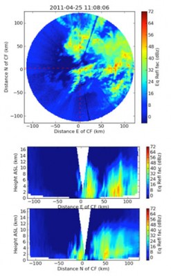
The scanning ARM precipitation radars produce measurements of raw radar moments in coordinates of the antenna’s azimuth and elevation as well as distance from the radar. Conversely, most numerical representations of the atmosphere tend to be in a Cartesian coordinate system using either height above mean sea level (or land surface in sigma coordinates) or pressure levels as a vertical scale. The new MMCG maps the antenna coordinate data to a Cartesian grid. In addition to providing the needed conversion for compatible scientific analyses, these data sets can be used to create data visualizations like this.
To hasten the availability of these data to the science community, this product has been released into the evaluation stage very early in the development life cycle. Supporting details about this data set, including algorithm sources and notes on known data issues and failure artifacts, are contained in the “README” file for the MMCG. This information and the data set are available under MMCG in the Evaluation VAP webpage.
Users are strongly encouraged to send feedback on this preliminary product to Scott Collis, ARM precipitation radar instrument translator, at scollis@anl.gov. Comments received during the 6-month evaluation period will be used to improve MMCG before full release and will guide the prioritization and development of future radar data products.
The ARM Climate Research Facility is a DOE Office of Science user facility. The ARM Facility is operated by nine DOE national laboratories, including .
Keep up with the Atmospheric Observer
Updates on ARM news, events, and opportunities delivered to your inbox
ARM User Profile
ARM welcomes users from all institutions and nations. A free ARM user account is needed to access ARM data.


